 TEST - Slovenski INSPIRE metapodatkovni sistem
eENVplus Surface Geology - web services
The pilot aplication service for calculating landslide susceptibility map and map of flood prone area.The harmonized geological map of Slovenia is a simplified version of the 1:250,000 scale Geological Map of Slovenia (Buser, 2009), which was compiled using the Basic Geological Map of Slovenia at a scale of 1: 100,000 (compiled by various authors between 1960's and 1980's) with the addition of new information by S. Buser. The map depicts the lithostratigraphic composition of Slovenia.The Basic Geological Map of Slovenia as a part of joint Basic Geological Map of SFR Yugoslavia presents lithological and stratigraphic characteristics of rocks, their relationships, age and other. It is a key to the understanding of the geology of Slovenia. It consists of 23 sheets at a scale of 1: 100,000.
|
|
Citation proposal
Geološki zavod Slovenije Geološki zavod Slovenije (2015) . eENVplus Surface Geology - web services. https://eprostor.gov.si/imps-test/srv/api/records/12e038a6-f4ce-4f2f-8d5e-82c7db88de2d |
- Identification
- Distribution
- Quality
- Spatial rep.
- Ref. system
- Content
- Portrayal
- Metadata
- Md. constraints
- Md. maintenance
- Schema info
Identification
Identification info
Service Identification (19119)
Citation
- Date ( Publication )
- 2015-01-01
- Date ( Revision )
- 2015-01-01
- Date ( Creation )
- 2015-01-01
Owner
Geological Survey of Slovenia
-
Geološki zavod Slovenije
Geološki zavod Slovenije
( )
Dimičeva ulica 14
Ljubljana
1000
Slovenija
Point of contact
Custodian
- ThIST - Italian Thesaurus of Earth Sciences (Version: Linked Data 1.0)
-
- construction materials
- sedimentary rocks
- sediments
- igneous rocks
- metamorphic rocks
- tectonic elements
- faults
- foliation
- geochronology
- stratigraphic units
- lithology
- lithostratigraphic unit
- relative age
- stratigraphy
- geology
- geologic maps
- depositional environment
- GEMET (version 3.1, 2012-07-20)
-
- natural environment
- geological process
- INSPIRE feature concept dictionary (Version: Linked Data 1.0)
-
- Geologic Event
- Geologic Feature
- Geologic Unit
- EARTh- Enviromental Applications Reference THesaurus (Version: Linked Data 1.5)
-
- *geolithological constituents*
- ISO - 19119 geographic services taxonomy
-
- infoMapAccessService
- Keywords
-
- eENVplus
- INSPIRE
- Keywords
-
- EP09
- GEMET - INSPIRE themes, version 1.0
-
- Geology
- Spatial scope ( Theme )
-
- National
- Use limitation
- geossNonCommercial
Legal constraints
- Use limitation
- Data is available under a Creative Commons - Attribution 4.0 International (CC BY 4.0) license. (https://creativecommons.org/licenses/by/4.0)
- Access constraints
- Other restrictions
- Use limitation
- (e) intellectual property rights
- Use limitation
- Data is available under a Creative Commons - Attribution 4.0 International (CC BY 4.0) license. (https://creativecommons.org/licenses/by/4.0)
- Service Type
- view
Extent
N
S
E
W
))
Coupled Resource
- Operation Name
- GetCapabilities
- Identifier
- 52535255-775d-4549-b6ea-9a6c0b9d50b0
Contains Operations
No information provided.
Distribution
Distribution
- Distribution format
-
- WFS (1.1.0 )
Digital transfer options
- OnLine resource
-
eENVplus_1M_surface_GeologicUnit
eENVplus GeoZS 1M surface Geologic Unit
- OnLine resource
-
eENVplus
GeoZS superficial geology
- OnLine resource
-
eENVplus_100k_surface_GeologicUnit
eENVplus GeoZS 100k surface Geologic Unit
- OnLine resource
-
eENVplus_100k_surface_GeologicUnit
eENVplus GeoZS 100k surface Geologic Unit
- OnLine resource
-
eENVplus_1M_surface_GeologicUnit
eENVplus GeoZS 1M surface Geologic Unit
Quality
Data quality
Scope
- Hierarchy level
- Service
- Other
- storitev
Conformance result
Citation
- Date ( Publication )
- 2009-10-19
- Explanation
- See the referenced specification
- Pass
- true
Conformance result
- Explanation
- See the referenced specification.
Ref. system
- Reference system identifier
- EPSG / http://www.opengis.net/def/crs/EPSG/0/4258
Metadata
Metadata
- File identifier
- 12e038a6-f4ce-4f2f-8d5e-82c7db88de2d XML
- Metadata language
- English
- Character set
- UTF8
- Hierarchy level
- Service
- Hierarchy level name
- infoMapAccessService
- Date stamp
- 2022-12-09T15:11:20
- Metadata standard name
- ISO19115
- Metadata standard version
- 2003/Cor.1:2006
Metadata author
No information provided.
Point of contact
Overviews
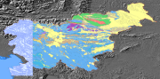
thumbnail
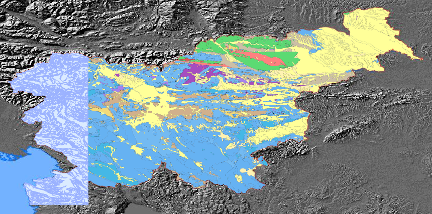
large_thumbnail
Provided by

Views
12e038a6-f4ce-4f2f-8d5e-82c7db88de2d
Access to the portal
Read here the full details and access to the data.
Associated resources
Not available