 TEST - Slovenski INSPIRE metapodatkovni sistem
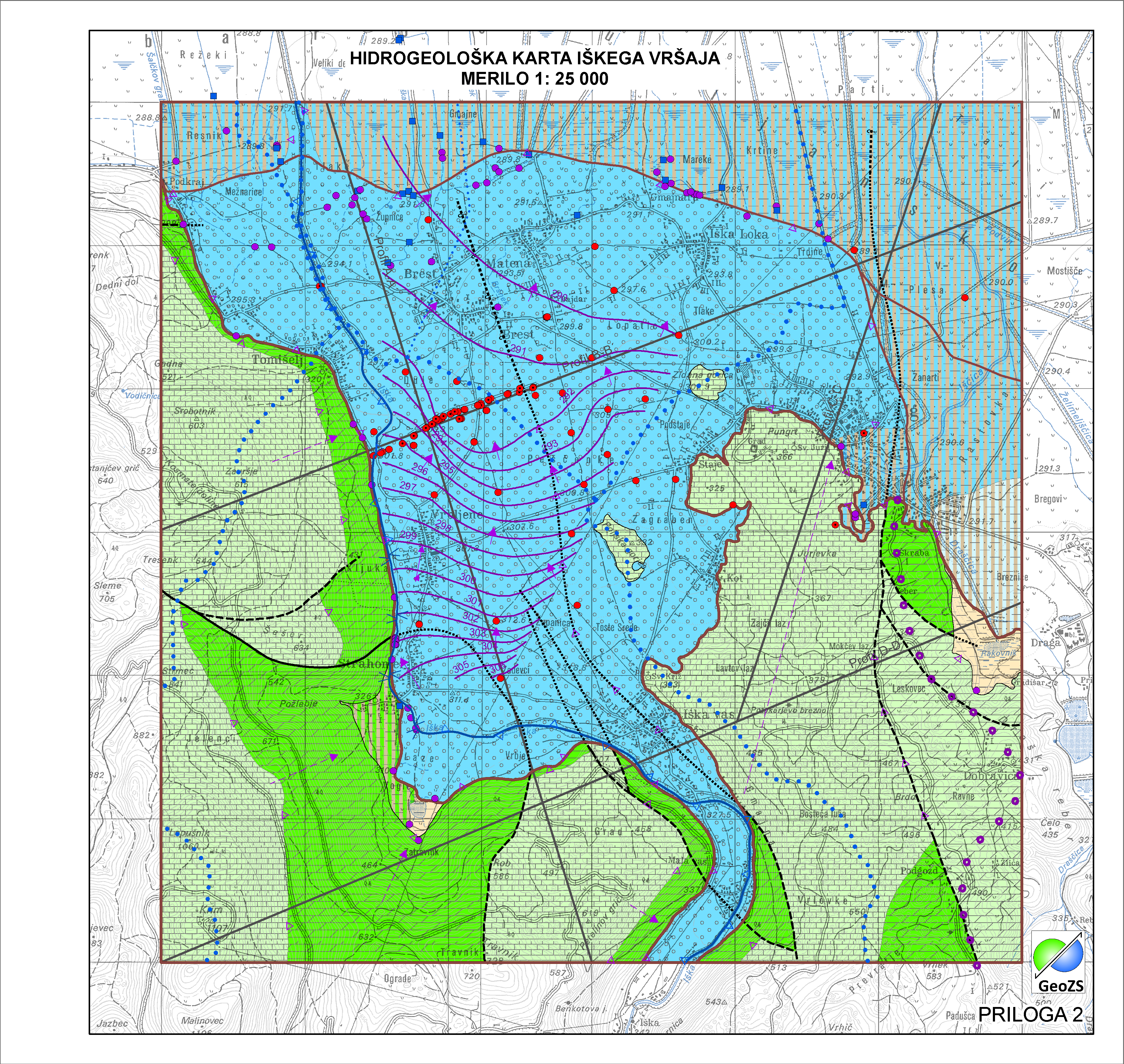
Hydrogeological map of Iška alluvial fan 1:25 000 - Hydrogeological basement
Relief karbonatne podlage pod aluvijalnim prodnim zasipom Iškega vršaja z obrobjem je narejena na popravljenem modelu po Menceju (1990), ki je bila narejena v okviru Projekta INCOME (Janža e tal., 2012). Za potrebe hidrogeološke karta Iškega vršaja je bila podlaga popravljena s dodatnimi seizmičnimi podatki in podatki iz vrtin projekta INCOME. Podlaga je pripravljena v grid obliki 5x5.
|
|
Citation proposal
Geološki zavod Slovenije Geological Survey of Slovenia - Geološki zavod Slovenije (2015) . Hydrogeological map of Iška alluvial fan 1:25 000 - Hydrogeological basement. https://eprostor.gov.si/imps-test/srv/api/records/23f847d4-80ee-489c-961b-2dde6a8971a9 |
Simple
- Alternate title
- Hydrogeological map of Iška alluvial fan 1:25 000
- Alternate title
- Hydrogeological basement
- Date ( Creation )
- 2014-11-18
- Date ( Publication )
- 2015-01-01
- Identifier
- SI.GEOZS.HG25.HGPODLAGA / 9de65560-8e53-48ab-8db8-b935486a89db
- Presentation form
- Digital map
- Purpose
- Hidrogeološka podlaga je namenjena za določanje hidrogeoloških razmer.
Author
Point of contact
Geological Survey of Slovenia
-
dr. Nina Mali
Nina Mali, PhD
(Head of Groundwater-Hydrogeology Department )
Dimičeva ulica 14
Ljubljana
1000
Slovenija
Custodian
- Maintenance and update frequency
- As needed
- Keywords ( Discipline )
-
- hydrogeology
- Keywords ( Theme )
-
- hydrogeological basement
- aquifer type
- Iška alluvial fan
- hydrogeological map
- Keywords ( Place )
-
- Slovenia
- Ig
- Keywords ( Discipline )
-
- geology
- hidrogeologija
- Keywords ( Theme )
-
- INSPIRE
- GEMET - INSPIRE themes, version 1.0 GEMET - INSPIRE themes, version 1.0 ( Theme )
-
- Geology
- Spatial scope ( Theme )
-
- Local
- Use limitation
- Data is available under a Creative Commons - Attribution 4.0 International (CC BY 4.0) license. (https://creativecommons.org/licenses/by/4.0)
- Access constraints
- Copyright
- Use limitation
- Hidrogeološka karta Iškega vršaja v merilu 1:25000. Hidrogeološka karta še ni v uporabi "OSNUTEK"
- Use limitation
- Hidrogeološka karta še ni v uporabi "OSNUTEK"
- Use limitation
- Data is available under a Creative Commons - Attribution 4.0 International (CC BY 4.0) license. (https://creativecommons.org/licenses/by/4.0)
- Spatial representation type
- Grid
- Denominator
- 25000
- Metadata language
- Slovenian
- Metadata language
- Slovenian
- Character set
- UTF8
- Topic category
-
- Geoscientific information
- Environment description
- ArcGIS 10.1
- Description
- Slovenia
N
S
E
W
))
- Begin date
- 2014-06-01
- End date
- 2014-12-31
- Supplemental Information
- Reference system identifier
- MGI / Slovene National Grid (EPSG:3787)
- Reference system identifier
- WGS 84 (EPSG:4326)
- Reference system identifier
- Slovenia 1996 / Slovene National Grid (EPSG:3794)
- Reference system identifier
- http://www.opengis.net/def/crs/EPSG/0/4258
- Topology level
- Geometry only
- Distribution format
-
- ESRI Shapefile (1.0 )
- Hierarchy level
- Dataset
Conformance result
- Date ( Publication )
- 2010-12-08
- Explanation
- Podatek je v skladu z INSPIRE za Geologijo
- Pass
- true
- Statement
- HG Podlaga
- Description
- HG Podlaga
gmd:MD_Metadata
- File identifier
- 23f847d4-80ee-489c-961b-2dde6a8971a9 XML
- Metadata language
- Slovenian
- Character set
- UTF8
- Hierarchy level
- Dataset
- Date stamp
- 2021-05-06T11:27:27
- Metadata standard name
- ISO 19115:2003/19139
- Metadata standard version
- 1.0
Point of contact
Geological Survey of Slovenia
-
Matija Krivic
Matija Krivic
( )
Dimičeva ulica 14
Ljubljana
1000
Slovenija
+386 1 280 97 53
- Website
-
The main purpose of the Geological Survey of Slovenia is to provide geological expertise and information about the geology of Slovenia. Geological data are fundamental for decision making in fields such as: protection of human health and the environment, drinking water supply, geohazard mitigation, urban planning, mineral resources exploration and exploitation, etc.
The main purpose of the Geological Survey of Slovenia is to provide geological expertise and information about the geology of Slovenia. Geological data are fundamental for decision making in fields such as: protection of human health and the environment, drinking water supply, geohazard mitigation, urban planning, mineral resources exploration and exploitation, etc.
- Dataset URI
Overviews
large_thumbnail
Provided by

Views
23f847d4-80ee-489c-961b-2dde6a8971a9
Access to the portal
Read here the full details and access to the data.
Associated resources
Not available