 TEST - Slovenski INSPIRE metapodatkovni sistem
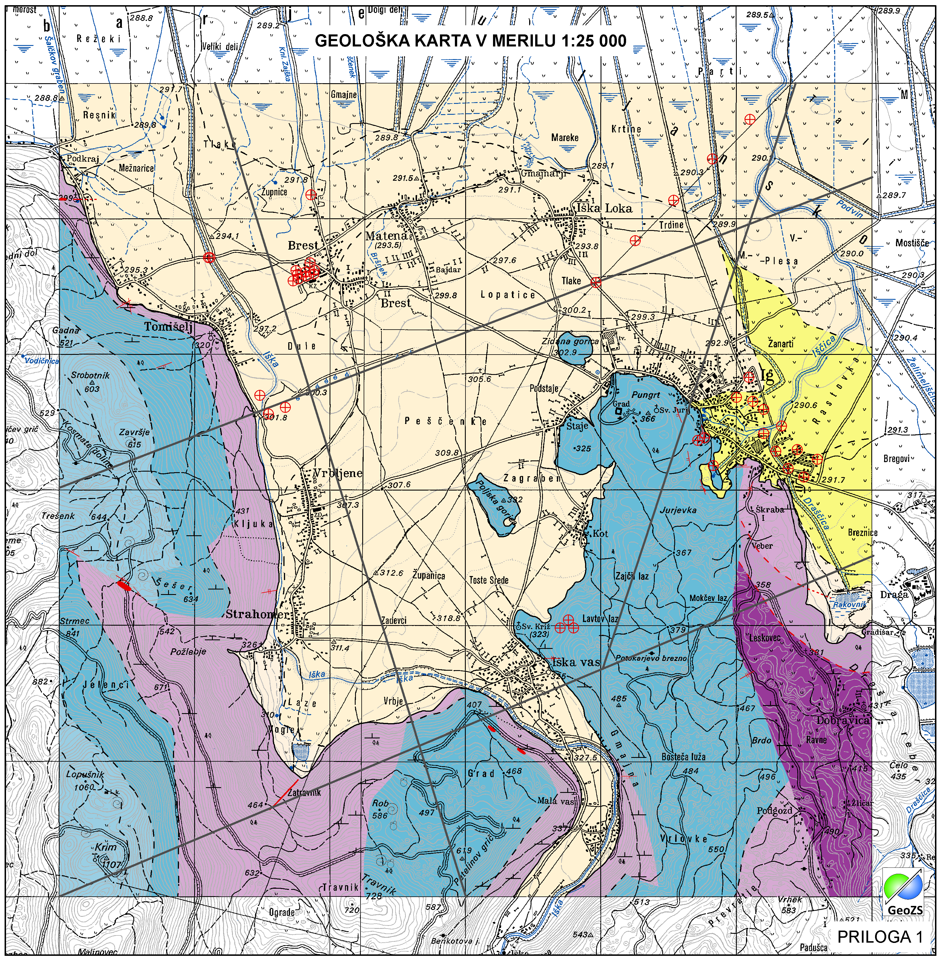
Geological map of Iška alluvial fan 1:25 000 - Geological units
Geological Units are polygons, defined by equal composition (lithology) and age.
|
|
Citation proposal
Geološki zavod Slovenije Geological Survey of Slovenia - Geološki zavod Slovenije (2014) . Geological map of Iška alluvial fan 1:25 000 - Geological units. https://eprostor.gov.si/imps-test/srv/api/records/9552a47b-9d8a-40cf-bdf3-b8b300c3601b |
INSPIRE
Identification
- File identifier
- 9552a47b-9d8a-40cf-bdf3-b8b300c3601b XML
- Hierarchy level
- Dataset
- Identifier
- SI.GEOZS.GE25.GEOLENOTE / 1ff2643b-3a4e-4ad1-b0b5-9e97209b601e
- Metadata language
- Slovenian
- Metadata language
- Slovenian
- Reference system identifier
- MGI / Slovene National Grid (EPSG:3787)
- Reference system identifier
- WGS 84 (EPSG:4326)
- Reference system identifier
- Slovenia 1996 / Slovene National Grid (EPSG:3794)
- Reference system identifier
- http://www.opengis.net/def/crs/EPSG/0/4258
Classification of data and services
- Topic category
-
- Geoscientific information
Classification of data and services
Coupled resource
Coupled resource
Classification of data and services
Coupled resource
Coupled resource
Keywords
- GEMET - INSPIRE themes, version 1.0 GEMET - INSPIRE themes, version 1.0 ( Theme )
-
- Geology
- Spatial scope ( Theme )
-
- Local
Other keywords
- Keywords ( Discipline )
-
- geology
- Regional geology
- hydrogeology
- Keywords ( Theme )
-
- geology
- lithostratigraphy
- geological units
- Keywords ( Place )
-
- Iška alluvial fan
- Slovenia
- Ig
- Keywords ( Theme )
-
- INSPIRE
Geographic coverage
N
S
E
W
))
Temporal reference
Temporal extent
- Begin
- 2014-06-01
- End
- 2014-12-31
Temporal extent
- Date ( Creation )
- 2014-11-18
- Date ( Publication )
- 2014-11-28
Quality and validity
- Lineage
- Geological units
Spatial resolution
Spatial resolution (scale)
- Denominator
- 25000
Spatial resolution (distance)
Md. maintenance
- Maintenance and update frequency
- As needed
Coordinate Reference System
- code
- MGI / Slovene National Grid (EPSG:3787)
- code
- WGS 84 (EPSG:4326)
- code
- Slovenia 1996 / Slovene National Grid (EPSG:3794)
Encoding
- Format
- ESRI Shapefile
- Version
- 1.0
- Character set
- UTF8
- Spatial representation type
- Vector
Conformity
Conformance result
- Date ( Publication )
- 2010-12-08
- Explanation
- Podatek je v skladu z INSPIRE za Geologijo
- Pass
- true
Conformity
Conformance result
- Date ( Publication )
- 2010-12-08
- Explanation
- Podatek je v skladu z INSPIRE za Geologijo
- Pass
- true
constraintsRelatedToAccessAndUse
Use limitation
Access constraints
Access constraints
constraintsRelatedToAccessAndUse
Use limitation
Access constraints
Access constraints
Responsible organization (s)
Author
Point of contact
Geological Survey of Slovenia
-
dr. Matevž Novak
Matevž Novak, PhD
( )
Dimičeva ulica 14
Ljubljana
1000
Slovenija
Custodian
Responsible organization (s)
Author
Point of contact
Geological Survey of Slovenia
-
dr. Matevž Novak
Matevž Novak, PhD
( )
Dimičeva ulica 14
Ljubljana
1000
Slovenija
Custodian
Metadata information
Point of contact
Geological Survey of Slovenia
-
Blaž Milanič
Blaž Milanič
Dimičeva ulica 14
Ljubljana
1000
Slovenija
(01) 280 97 53
- Website
-
The main purpose of the Geological Survey of Slovenia is to provide geological expertise and information about the geology of Slovenia. Geological data are fundamental for decision making in fields such as: protection of human health and the environment, drinking water supply, geohazard mitigation, urban planning, mineral resources exploration and exploitation, etc.
The main purpose of the Geological Survey of Slovenia is to provide geological expertise and information about the geology of Slovenia. Geological data are fundamental for decision making in fields such as: protection of human health and the environment, drinking water supply, geohazard mitigation, urban planning, mineral resources exploration and exploitation, etc.
- Date stamp
- 2021-11-10T13:32:42
SDS
Conformance class 1: invocable
Access Point URL
Endpoint URL
Technical specification
Conformance class 2: interoperable
Coordinate reference system
Quality of Service
Access constraints
Limitation
Use constraints
Limitation
Responsible custodian
Contact for the resource
Conformance class 3: harmonized
Overviews
large_thumbnail
Provided by

Views
9552a47b-9d8a-40cf-bdf3-b8b300c3601b
Access to the portal
Read here the full details and access to the data.
Associated resources
Not available