 TEST - Slovenski INSPIRE metapodatkovni sistem
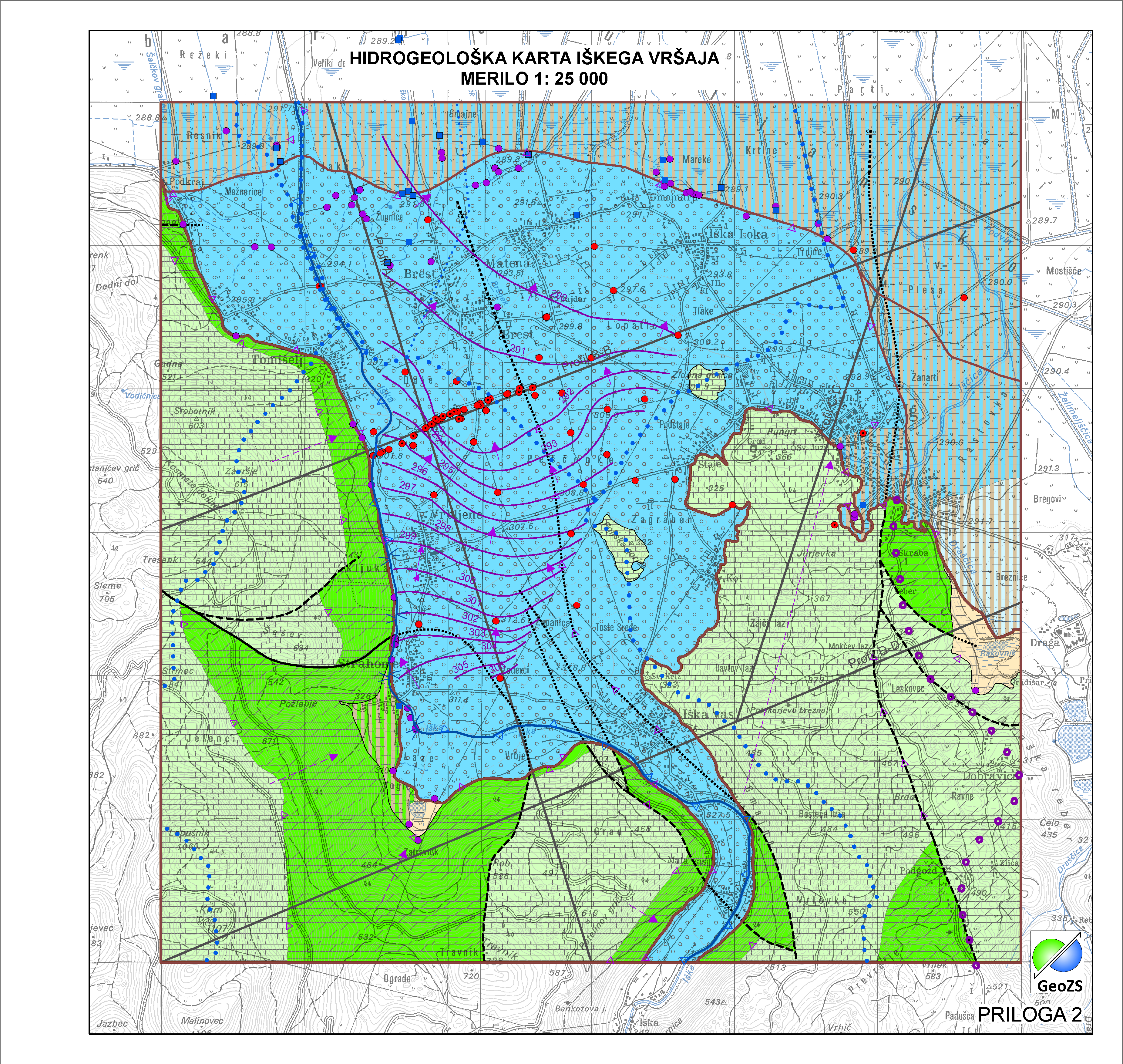
Hydrogeological map of Iška alluvial fan 1:25 000 - Hydrogeological Object Man Made
Hidrogeološki objekti vrtine predstavljajo hidrogeološke objekte, ki jih je naredil človek.
|
|
Citation proposal
Geološki zavod Slovenije Geological Survey of Slovenia (2015) . Hydrogeological map of Iška alluvial fan 1:25 000 - Hydrogeological Object Man Made. https://eprostor.gov.si/imps-test/srv/api/records/f3df3cb2-40df-4c82-bb1b-5e2e50dd670f |
- Identification
- Distribution
- Quality
- Spatial rep.
- Ref. system
- Content
- Portrayal
- Metadata
- Md. constraints
- Md. maintenance
- Schema info
Identification
Data identification
Citation
- Alternate title
- Hydrogeological map of Iška alluvial fan 1:25 000
- Alternate title
- Hydrogeological Object Man Made
- Date ( Creation )
- 2014-11-18
- Date ( Publication )
- 2015-01-01
- Identifier
- SI.GEOZS.HG25.HGOBJU / 4c2012a2-562f-482d-81e8-19f7a174b030
- Presentation form
- Digital map
- Purpose
- Glavni namen hidrogeoloških objektov je izkoriščanje podzemne vode ali za ugotavljanje hidrogeološklih značilnosti ter meritve in analiziranje podzemen vode.
Author
Point of contact
Geological Survey of Slovenia
-
dr. Nina Mali
Nina Mali, PhD
(Head of Groundwater-Hydrogeology Department )
Dimičeva ulica 14
Ljubljana
1000
Slovenija
- Maintenance and update frequency
- As needed
- Keywords ( Discipline )
-
- hydrogeology
- Keywords ( Theme )
-
- borehole
- well
- aquifer type
- hydrogeological map
- Iška alluvial fan
- hydrogeological object
- Keywords ( Place )
-
- Slovenia
- Ig
- Keywords ( Discipline )
-
- geology
- Hydrogeology
- Keywords ( Theme )
-
- INSPIRE
- GEMET - INSPIRE themes, version 1.0 GEMET - INSPIRE themes, version 1.0 ( Theme )
-
- Geologija
- Spatial scope ( Theme )
-
- Local
Legal constraints
- Access constraints
- Copyright
- Use limitation
- Hidrogeološka karta Iškega vršaja v merilu 1:25000. Hidrogeološka karta še ni v uporabi "OSNUTEK"
- Use limitation
- Data is available under a Creative Commons - Attribution 4.0 International (CC BY 4.0) license. (https://creativecommons.org/licenses/by/4.0)
Constraints
- Use limitation
- Hidrogeološka karta še ni v uporabi "OSNUTEK"
- Use limitation
- Data is available under a Creative Commons - Attribution 4.0 International (CC BY 4.0) license. (https://creativecommons.org/licenses/by/4.0)
- Spatial representation type
- Vector
- Denominator
- 25000
- Metadata language
- Slovenian
- Metadata language
- English
- Character set
- UTF8
- Topic category
-
- Geoscientific information
- Environment description
- ArcGIS 10.1
Extent
- Description
- Slovenia
N
S
E
W
))
- Begin date
- 2014-06-01
- End date
- 2014-12-31
- Supplemental Information
Quality
Data quality
- Hierarchy level
- Dataset
Conformance result
Citation
- Date ( Publication )
- 2010-12-08
- Explanation
- Podatek je v skladu z INSPIRE za Geologijo
- Pass
- true
Lineage
- Statement
- Hidrogeološka karta IŠKEGA VRŠAJA 1: 25 000 - Hidrogeološki objekti VRTINE so hidrogeološki objekti, ki podajajo hidrogeološke lastnosti karte.
- Description
- Glavni namen hidrogeoloških objektov je raziskava hidrogeološklih značilnosti.
Spatial rep.
- Topology level
- Geometry only
Ref. system
- Reference system identifier
- EPSG / MGI / Slovene National Grid (EPSG:3787) / 7.4
- Reference system identifier
- EPSG / WGS 84 (EPSG:4326) / 7.4
- Reference system identifier
- EPSG / Slovenia 1996 / Slovene National Grid (EPSG:3794) / 7.4
- Reference system identifier
- http://www.opengis.net/def/crs/EPSG/0/4258
Metadata
Metadata
- File identifier
- f3df3cb2-40df-4c82-bb1b-5e2e50dd670f XML
- Metadata language
- Slovenian
- Character set
- UTF8
- Hierarchy level
- Dataset
- Date stamp
- 2021-11-10T11:12:31
- Metadata standard name
- ISO 19115:2003/19139
- Metadata standard version
- 1.0
Point of contact
Geological Survey of Slovenia
-
Matija Krivic
Matija Krivic
Dimičeva ulica 14
Ljubljana
1000
Slovenija
+386 1 280 97 53
- Website
-
The main purpose of the Geological Survey of Slovenia is to provide geological expertise and information about the geology of Slovenia. Geological data are fundamental for decision making in fields such as: protection of human health and the environment, drinking water supply, geohazard mitigation, urban planning, mineral resources exploration and exploitation, etc.
The main purpose of the Geological Survey of Slovenia is to provide geological expertise and information about the geology of Slovenia. Geological data are fundamental for decision making in fields such as: protection of human health and the environment, drinking water supply, geohazard mitigation, urban planning, mineral resources exploration and exploitation, etc.
- Dataset URI
Md. constraints
- Use limitation
- "Conditions For Access And Use"
Md. maintenance
- Maintenance and update frequency
- As needed
Overviews
large_thumbnail
Provided by

Views
f3df3cb2-40df-4c82-bb1b-5e2e50dd670f
Access to the portal
Read here the full details and access to the data.
Associated resources
Not available