 TEST - Slovenski INSPIRE metapodatkovni sistem
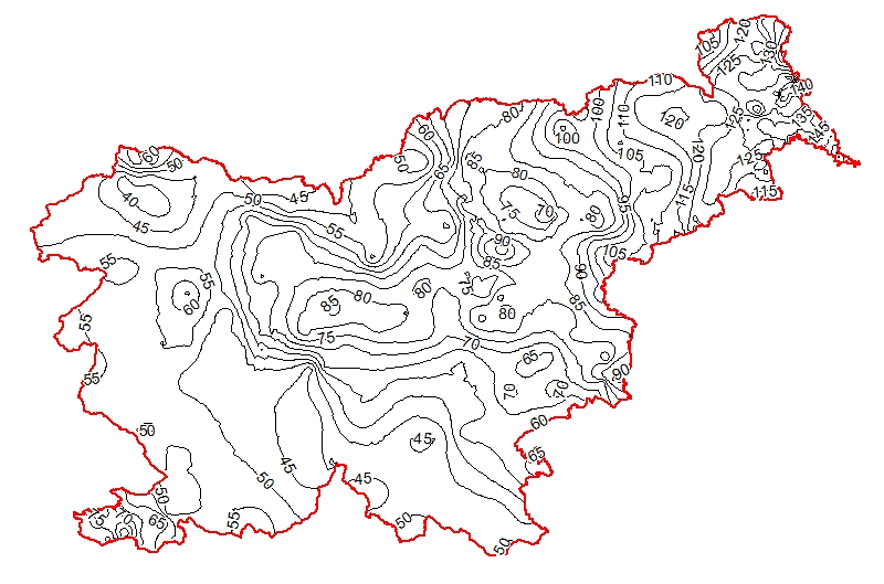
Geothermal map - Temperature lines at 3000 m depth
The underground geothermal conditions can be presented, irrespective of the aquifers' position, with the appropriate geothermal maps. This map represents the expected temperature lines at a depth of 3000 m and is derived from Geothermal map - Expected temperatures at a depth of 3000 m, which is made with data from 214 boreholes. It is made on the basis of measured temperatures in accessible boreholes throughout the country. However, since the temperature field depends on the geological structure in the depths and tectonic characteristics, the course of the isotherms is a result of many influences, such as thermal conductivity of rocks, permeability and fracturing of rocks, all of which are reflected in the measured temperatures in boreholes. In this depth also a radiogenic heat production in the rocks has smaller influence. The distribution of boreholes, which were useful for the measurement of temperature, is very uneven and different as regard the depths. Following the expected temperatures at a depth of 3000 m a stronger positive anomaly is in the northeastern part of Slovenia, from the line Maribor-Rogatec to the east, while in the eastern part of the Krka basin there is no anomaly any more. In the northeastern part of the country the anomaly is the result of the thinning of the Earth's crust and greater conductive heat flow from the Earth's mantle. Elsewhere temperatures are much lower.
|
|
Citation proposal
Geološki zavod Slovenije (2015) . Geothermal map - Temperature lines at 3000 m depth. https://eprostor.gov.si/imps-test/srv/api/records/fdf5cd43-e8e4-4472-a8c2-019c624fd938 |
INSPIRE
Identification
- File identifier
- fdf5cd43-e8e4-4472-a8c2-019c624fd938 XML
- Hierarchy level
- Dataset
- OnLine resource
-
Temperature_line_Lines_at_3000m_depth
WMS - Temperature_line_Lines_at_3000m_depth
- OnLine resource
-
Temperature_line_Lines_at_3000m_depth
WMS - Temperature_line_Lines_at_3000m_depth
- OnLine resource
-
EGIP_EGIP_geothermal_map:Temperature_line_Lines_at_3000m_depth
WFS - Temperature line Lines at 3000m depth
- OnLine resource
-
EGIP_EGIP_geothermal_map:Temperature_line_Lines_at_3000m_depth
WFS - Temperature line Lines at 3000m depth
- OnLine resource
-
TempLine3000m.rar
Geothermal map - Temperature lines at 3000 m depth
- Identifier
- SI.GEOZS.GEOTERM.IZOTERM.3000m / 31dfd540-27e7-485b-b31c-e1f0eea849c8
- Metadata language
- Slovenian
- Reference system identifier
- http://www.opengis.net/def/crs/EPSG/0/4258
- Reference system identifier
- http://www.opengis.net/def/crs/EPSG/0/3034
- Reference system identifier
- http://www.opengis.net/def/crs/EPSG/0/3794
- Reference system identifier
- http://www.opengis.net/def/crs/EPSG/0/3912
- Reference system identifier
- http://www.opengis.net/def/crs/EPSG/0/4326
Classification of data and services
- Topic category
-
- Geoscientific information
Classification of data and services
Coupled resource
Coupled resource
Classification of data and services
Coupled resource
Coupled resource
Keywords
- GEMET - INSPIRE themes, version 1.0 GEMET - INSPIRE themes, version 1.0
-
- Energy resources
- Spatial scope ( Theme )
-
- National
Other keywords
- Keywords ( Place )
-
- Slovenia
- Keywords ( Theme )
-
- geology
- geothermal energy
- temperature map
- isoterms at 3000 m depth
- renewable energy resources
- Directive 2009/28/ES
- energy balance
- hydrogeology
- Keywords ( Theme )
-
- INSPIRE
- EGDI
- Keywords ( Discipline )
-
- Geothermics
Geographic coverage
N
S
E
W
))
Temporal reference
Temporal extent
- Begin
- 2012-12-31
- End
- 2015-07-16
Temporal extent
- Date ( Creation )
- 2012-12-31
- Date ( Publication )
- 2015-07-16
- Date ( Revision )
- 2015-07-16
Quality and validity
- Lineage
-
Authors:
mag. Dušan Rajver, univ.dipl.ing.geol., dr. Mitja Janža, univ.dipl.ing.geol., mag. Andrej Lapanje, univ.dipl.ing.geol.
Spatial resolution
Spatial resolution (scale)
- Denominator
- 100000
Spatial resolution (distance)
Md. maintenance
- Maintenance and update frequency
- As needed
Coordinate Reference System
Encoding
- Format
- ESRI Shapefile
- Version
- 9.3
- Format
- WMS
- Version
- 1.3.0
- Format
- WFS
- Version
- 1.1.0
- Character set
- UTF8
- Spatial representation type
- Vector
Conformity
Conformance result
- Date ( Publication )
- 2010-12-08
- Explanation
- Data is in accordance with the EGIP and Geothermal ERA-NET Information System.
- Pass
- true
Conformity
Conformance result
- Date ( Publication )
- 2010-12-08
- Explanation
- Data is in accordance with the EGIP and Geothermal ERA-NET Information System.
- Pass
- true
constraintsRelatedToAccessAndUse
Use limitation
- Use limitation
- Data is available under a Commons - Attribution 4.0 International (CC BY 4.0) license. (https://creativecommons.org/licenses/by/4.0)
Access constraints
Access constraints
constraintsRelatedToAccessAndUse
Use limitation
- Use limitation
- Data is available under a Commons - Attribution 4.0 International (CC BY 4.0) license. (https://creativecommons.org/licenses/by/4.0)
Access constraints
Access constraints
Responsible organization (s)
Owner
Distributor
Point of contact
Originator
- Website
- www.mzi.gov.si
Custodian
Responsible organization (s)
Owner
Distributor
Point of contact
Originator
- Website
- www.mzi.gov.si
Custodian
Metadata information
Point of contact
- Date stamp
- 2024-05-30T10:56:53
SDS
Conformance class 1: invocable
Access Point URL
Endpoint URL
Technical specification
Conformance class 2: interoperable
Coordinate reference system
Quality of Service
Access constraints
Limitation
Use constraints
Limitation
Responsible custodian
Contact for the resource
Conformance class 3: harmonized
Overviews
large_thumbnail
Provided by

Views
fdf5cd43-e8e4-4472-a8c2-019c624fd938
Access to the portal
Read here the full details and access to the data.
Associated resources
Not available