 Slovenski INSPIRE metapodatkovni sistem
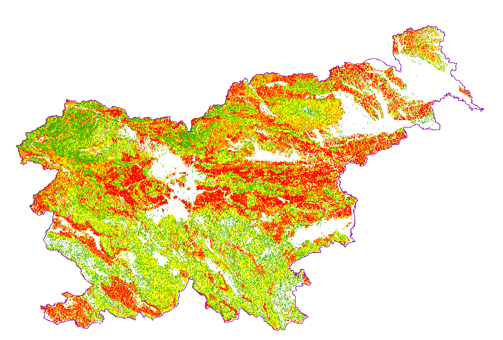
Landslide susceptibility map
Karta podaja potencialna plazovita območja za območje celotne Slovenije v šestih razredih verjetnosti pojavljanja plazov; ni verjetnosti, zelo majhna verjetnost, majhna verjetnost, srednja verjetnost, velika verjetnost, zelo velika verjetnost. Zanesljivost napovedi je približno 0,88.
|
|
Citation proposal
Geološki zavod Slovenije (2006) . Landslide susceptibility map. https://eprostor.gov.si/imps/srv/api/records/04b5a38e-ea78-4e68-aa36-9528d792d54a |
INSPIRE
Identification
- File identifier
- 04b5a38e-ea78-4e68-aa36-9528d792d54a XML
- Hierarchy level
- Dataset
- OnLine resource
-
ver_plaz
Verjetnost pojavljanja zemeljskih plazov
- Identifier
- SI.GEOZS.INZ.ZEMPLAZ / e030855e-e8b4-4443-88e1-e2aefbe3918b
- Metadata language
- Slovenian
- Reference system identifier
- http://www.opengis.net/def/crs/EPSG/0/3912
- Reference system identifier
- http://www.opengis.net/def/crs/EPSG/0/4326
- Reference system identifier
- http://www.opengis.net/def/crs/EPSG/0/4258
- Reference system identifier
- http://www.opengis.net/def/crs/EPSG/0/3034
- Reference system identifier
- http://www.opengis.net/def/crs/EPSG/0/3794
Classification of data and services
- Topic category
-
- Geoscientific information
Classification of data and services
Coupled resource
Coupled resource
Classification of data and services
Coupled resource
Coupled resource
Keywords
- GEMET - INSPIRE themes, version 1.0 GEMET - INSPIRE themes, version 1.0
-
- Natural risk zones
- Spatial scope ( Theme )
-
- National
Other keywords
- Keywords ( Place )
-
- Slovenia
- Keywords ( Theme )
-
- geology
- inženirska geologija
- landslide
- matematični model
- Keywords ( Theme )
-
- INSPIRE
- Keywords ( Discipline )
-
- Engineering geology
Geographic coverage
N
S
E
W
))
Temporal reference
Temporal extent
- Begin
- 2003-01-01
- End
- 2006-12-31
Temporal extent
- Date ( Creation )
- 2006-12-01
- Date ( Publication )
- 2006-12-01
- Date ( Revision )
- 2006-12-01
Quality and validity
- Lineage
- percentCoverage=100;geometricHarmonization=100;thematicHarmonization=100;geometricHarmonizationDescription;thematicHarmonizationDescription;
Spatial resolution
Spatial resolution (scale)
- Denominator
- 250000
Spatial resolution (distance)
- Distance
- 50 m
Md. maintenance
- Maintenance and update frequency
- As needed
Coordinate Reference System
Encoding
- Format
- ESRI Shapefile
- Version
- *
- Format
- WMS
- Version
- 1.3.0
- Character set
- UTF8
- Spatial representation type
- Grid
Conformity
Conformance result
- Date ( Publication )
- 2010-12-08
- Explanation
- See the referenced specification
- Pass
- false
Conformity
Conformance result
- Date ( Publication )
- 2010-12-08
- Explanation
- See the referenced specification
- Pass
- false
constraintsRelatedToAccessAndUse
Use limitation
useConstraint
Access constraints
Access constraints
constraintsRelatedToAccessAndUse
Use limitation
- Use limitation
- Karta verjetnosti pojavljanja plazov je bila izdelana v merilu 1 : 250.000 in ni uporabna za namene podrobnejših prostorskih analiz, načrtov ali drugih možnih uporab z izjemo preglednih analiz na nivoju celotne države. Kakršna koli nadaljnja uporaba karta je strokovno nesprejemljiva, škodljiva in neizogibno vodi k izpostavljanju prebivalstva in lastnine geološkim nevarnostim. Kot lastnik in avtor omenjene karte Geološki zavod Slovenije ne prevzema odgovornosti za njeno napačno uporabo. Geološki zavod Slovenije zaradi moralne zaveze k izdelavi in pravilni rabi kvalitetnih prostorskih podatkov ter zaradi varovanja avtorskih pravic in slabih izkušenj iz preteklosti od leta 2013 preprečuje uporabo omenjene karte za prostorsko načrtovanje tudi s pravnimi sredstvi.
- Use limitation
- Data is available under a Creative Commons - Attribution 4.0 International (CC BY 4.0) license. (https://creativecommons.org/licenses/by/4.0)
Access constraints
Access constraints
Responsible organization (s)
Point of contact
Owner
Distributor
Custodian
Responsible organization (s)
Point of contact
Owner
Distributor
Custodian
Metadata information
Point of contact
- Date stamp
- 2022-01-26T13:01:44
SDS
Conformance class 1: invocable
Access Point URL
Endpoint URL
Technical specification
Conformance class 2: interoperable
Coordinate reference system
Quality of Service
Access constraints
Limitation
Use constraints
Limitation
Responsible custodian
Contact for the resource
Conformance class 3: harmonized
Overviews
large_thumbnail
Provided by

Views
04b5a38e-ea78-4e68-aa36-9528d792d54a
Access to the portal
Read here the full details and access to the data.
Associated resources
Not available