 Slovenski INSPIRE metapodatkovni sistem
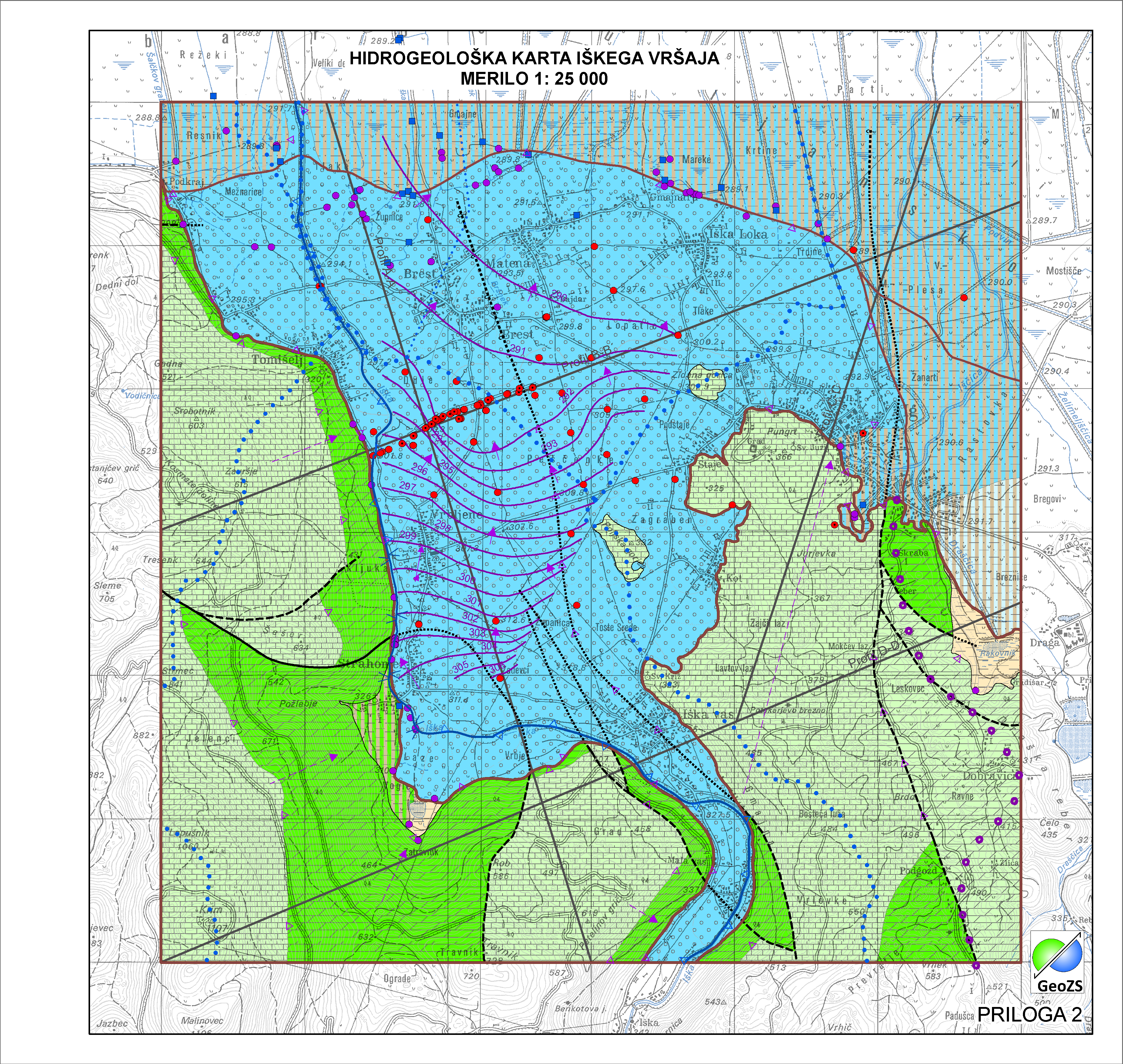
Hydrogeological map of Iška alluvial fan 1:25 000 - Hydrogeological Units
Data of Geological map were reclassified into classes of IAH classification on the base of hydrogeological characteristics. IAH classification is based on description of the hydrogeological units. Firstly, based on extensiveness and productivity and secondly on type of porosity.
The purpose is to provide assistance to the strategy of groundwater exploitation as to protection and water resources management.
|
|
Citation proposal
Geološki zavod Slovenije Geological Survey of Slovenia - Geološki zavod Slovenije (2015) . Hydrogeological map of Iška alluvial fan 1:25 000 - Hydrogeological Units. https://eprostor.gov.si/imps/srv/api/records/1ac3ffc0-293f-4e7f-8e5c-c341661ba0fb |
Simple
- Alternate title
- Hydrogeological map of Iška alluvial fan 1:25 000
- Alternate title
- Hydrogeological units
- Date ( Creation )
- 2014-11-18
- Date ( Publication )
- 2015-01-01
- Identifier
- SI.GEOZS.HG25.HGENOTE / 05bffdf3-d2eb-48de-b4e5-cc92a7267e2c
- Presentation form
- Digital map
- Purpose
- The main objective of the map is the identification and characterization of groundwater bodies on the national scale (level). Also offers support for groundwater resources management and protection.
Author
Point of contact
Custodian
- Maintenance and update frequency
- As needed
- Keywords ( Discipline )
-
- hydrogeology
- Keywords ( Theme )
-
- hydrogeology
- aquifer type
- type of porosity
- productivity
- Iška alluvial fan
- Keywords ( Place )
-
- Slovenia
- Ig
- Keywords ( Discipline )
-
- geology
- Hydrogeology
- Keywords ( Theme )
-
- INSPIRE
- GEMET - INSPIRE themes, version 1.0 GEMET - INSPIRE themes, version 1.0 ( Theme )
-
- Geology
- Spatial scope ( Theme )
-
- Local
- Access constraints
- Copyright
- Use limitation
- Hidrogeološka karta Iškega vršaja v merilu 1:25000. Hidrogeološka karta še ni v uporabi "OSNUTEK"
- Use limitation
- Data is available under a Creative Commons - Attribution 4.0 International (CC BY 4.0) license. (https://creativecommons.org/licenses/by/4.0)
- Use limitation
- Hidrogeološka karta še ni v uporabi "OSNUTEK"
- Use limitation
- Data is available under a Creative Commons - Attribution 4.0 International (CC BY 4.0) license. (https://creativecommons.org/licenses/by/4.0)
- Spatial representation type
- Vector
- Denominator
- 25000
- Metadata language
- Slovenian
- Metadata language
- English
- Character set
- UTF8
- Topic category
-
- Geoscientific information
- Environment description
- ArcGIS 10.1
- Description
- Slovenia
))
- Begin date
- 2014-06-01
- End date
- 2014-12-31
- Supplemental Information
- Reference system identifier
- EPSG / MGI / Slovene National Grid (EPSG:3787) / 7.4
- Reference system identifier
- EPSG / WGS 84 (EPSG:4326) / 7.4
- Reference system identifier
- EPSG / Slovenia 1996 / Slovene National Grid (EPSG:3794) / 7.4
- Reference system identifier
- http://www.opengis.net/def/crs/EPSG/0/4258
- Topology level
- Geometry only
- Hierarchy level
- Dataset
Conformance result
- Date ( Publication )
- 2010-12-08
- Explanation
- Podatek je v skladu z INSPIRE za Geologijo
- Pass
- true
- Statement
- Podatki Geološke karte Slovenije 1:25.000 so bili razdeljeni na osnovi njihovih hidrogeoloških lastnosti razvrščeni v razrede IAH klasifikacije. Priporočila IAH zajemajo hidrogeološke enote, pri katerih je težišče v prvi vrsti na opisu obsežnosti in izdatnosti vodonosnikov in v drugi vrsti na tipu poroznosti.
- Description
- Hidrogeološki podatki so nastali iz geološke karte Iškega vršaja v merilu 1:25000 z iterpretacijo v razrede IAH.
gmd:MD_Metadata
- File identifier
- 1ac3ffc0-293f-4e7f-8e5c-c341661ba0fb XML
- Metadata language
- Slovenian
- Character set
- UTF8
- Hierarchy level
- Dataset
- Date stamp
- 2021-05-05T12:59:15
- Metadata standard name
- ISO 19115:2003/19139
- Metadata standard version
- 1.0
Point of contact
- Website
-
The main purpose of the Geological Survey of Slovenia is to provide geological expertise and information about the geology of Slovenia. Geological data are fundamental for decision making in fields such as: protection of human health and the environment, drinking water supply, geohazard mitigation, urban planning, mineral resources exploration and exploitation, etc.
The main purpose of the Geological Survey of Slovenia is to provide geological expertise and information about the geology of Slovenia. Geological data are fundamental for decision making in fields such as: protection of human health and the environment, drinking water supply, geohazard mitigation, urban planning, mineral resources exploration and exploitation, etc.
- Dataset URI
Overviews
Provided by
