 Slovenski INSPIRE metapodatkovni sistem
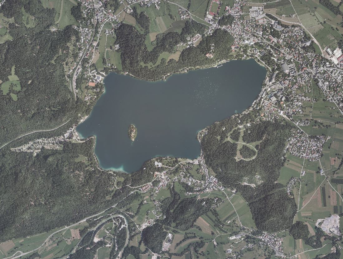
Orthophoto
An orthophoto is an aerial photograph that has been transformed from a central to an orthogonal projection by taking into account terrain relief data and the absolute orientation of the aerial photographs. In this process, the effects of the camera optics, camera tilt, and terrain undulation are removed. Orthophotos are metrically comparable to line maps, and their sheet division corresponds to that of TTN5. All orthophotos are available in TIFF format.
Different orthophotos are produced according to spatial resolution and colour spectrum:
DOF025 – colour (RGB) orthophoto with a ground sampling distance (GSD) of 0.25 m
DOF050 – colour (RGB) orthophoto with a ground sampling distance (GSD) of 0.50 m
DOF050IR – colour near-infrared orthophoto (IR, R and G) with a ground sampling distance (GSD) of 0.50 m
|
|
Citation proposal
Geodetska uprava Republike Slovenije Geodetska uprava Republike Slovenije . Orthophoto. https://eprostor.gov.si/imps/srv/api/records/1e0f54cf-9303-4140-8c20-352d5468c0b3 |
- Identification
- Distribution
- Quality
- Spatial rep.
- Ref. system
- Content
- Portrayal
- Metadata
- Md. constraints
- Md. maintenance
- Schema info
Identification
Data identification
Citation
- Date ( Creation )
- 1994-01-01
- Identifier
- SI.GURS.DOF / d9aed583-ad17-4038-91a7-806c7779030d
- Keywords
-
- ortofoto, podobe/osnovne karte/pokrovnost
- Spatial scope Spatial scope ( Theme )
-
- National
- GEMET - INSPIRE themes, version 1.0 GEMET - INSPIRE themes, version 1.0 ( Theme )
-
- Orthoimagery
- Keywords ( Theme )
-
- Podatki velike vrednosti
- theme.high-value-dataset-category.rdf theme.high-value-dataset-category.rdf ( Theme )
-
- Orthoimagery
Legal constraints
- Use constraints
- Other restrictions
- Use limitation
- Splošni pogoji uporabe geodetskih podatkov: https://www.e-prostor.gov.si/dostopi/javni-dostop/?acitem=1821-1822
- Use limitation
- Podatki so dostopni pod Creative Commons - Attribution 4.0 International (CC BY 4.0) licenco. (https://creativecommons.org/licenses/by/4.0)
Legal constraints
- Access constraints
- Other restrictions
- Use limitation
- No limitations
- Spatial representation type
- Grid
- Distance
- 0.5 m
- Distance
- 0.25 m
- Metadata language
- Slovenian
- Topic category
-
- Imagery base maps earth cover
))
Distribution
Distribution
- Distribution format
-
-
TIFF
( )
- Specification
-
TIFF
( )
Digital transfer options
- OnLine resource
- Portal Prostor
- OnLine resource
- Aplikacija JGP za prenos brezplačnih podatkov
- OnLine resource
- Aplikacija Javni vpogled
- OnLine resource
-
SI.GURS.ZPDZ:OI.OrthoimageCoverage
SI.GURS.ZPDZ:PREGLEDNI_DOF
Quality
Data quality
- Hierarchy level
- Dataset
Conformance result
Citation
- Date ( Publication )
- 2010-12-08
Identifier
- Projection
- Codespace
- EU
- Explanation
- Glej referenčno specifikacijo
- Pass
- true
Conformance result
Citation
- Date ( Publication )
- 2014-04-11
- Identifier
- SOP / 2014-01-0962
- Explanation
- Glej referenčno specifikacijo
- Pass
- true
Conformance result
Citation
- Date ( Publication )
- 2022-12-21
Identifier
- Projection
- Codespace
- EU
- Explanation
- Glej referenčni predpis: http://data.europa.eu/eli/reg_impl/2023/138/oj
- Pass
- true
- Statement
-
Vir za izdelavo ortofota so podatki Cikličnega aerofotografiranja Slovenije (CAS). Pri ortorektifikaciji se od 2015 uporabljajo podatki lidarskega snemanja Slovenije (DMR1), pred tem se je uporabljal DMV5, pred letom 2006 pa DMR25.
Najnovejši podatki so iz let 2023 - 2025, cikel obnove pa je 2-4 leta.
Ortofoti se izdelujejo v novem državnem koordinatnem sistemu D96/TM, lokacijske datoteke so na voljo tudi v starem državnem koordinatnem sistemu D48.
Zahtevana točnost ortofotov je RMSE (1 sigma) < 1,0m, za ortofote izdelane od leta 2015 do 2016 je RMSE (1 sigma) < 0,75m, za ortofote izdelane od leta 2017 dalje pa je geometrična točnost predpisana v skladu s standardom ASPRS (ASPRS Positional Accuracy Standards for Digital Geospatial Data, Edition 1, Version 1.0., November, 2014) in sicer: 1,21m s 95% intervalom zaupanja.
Ref. system
- Reference system identifier
- http://www.opengis.net/def/crs/EPSG/0/3794
- Reference system identifier
- EPSG / http://www.opengis.net/def/crs/EPSG/0/3912 / 7.9
Metadata
Metadata
- File identifier
- 1e0f54cf-9303-4140-8c20-352d5468c0b3 XML
- Metadata language
- Slovenian
- Hierarchy level
- Dataset
- Date stamp
- 2026-05-27T14:53:59
- Metadata standard name
- ISO 19115:2003/19139
- Metadata standard version
- 1.0
Overviews
Provided by
