 Slovenski INSPIRE metapodatkovni sistem
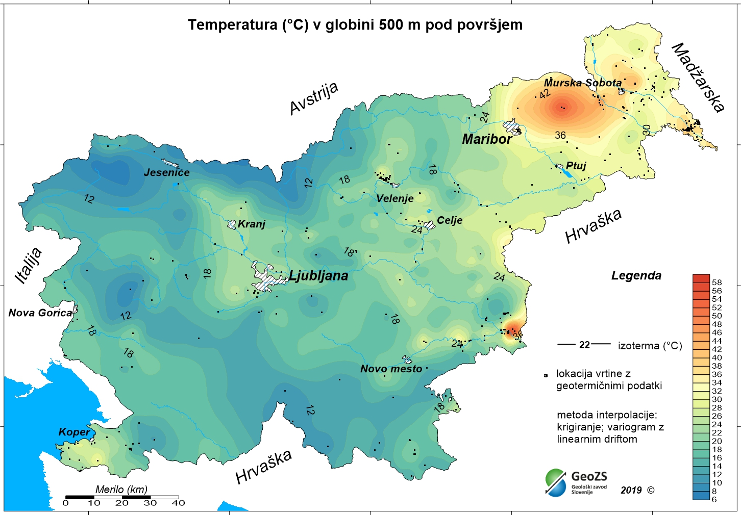
Geothermal map - Expected temperatures at a depth of 500 m
The underground geothermal conditions can be presented, irrespective of the aquifers' position, with the appropriate geothermal maps. This map represents the expected temperatures at a depth of 500 m and is made with data from 354 boreholes. It is made on the basis of measured temperatures in accessible boreholes throughout the country. However, since the temperature field depends on the geological structure in the depths and tectonic characteristics, the course of the isotherms is a result of many influences, such as thermal conductivity of rocks, permeability and fracturing of rocks, all of which are reflected in the measured temperatures in boreholes. The distribution of boreholes, which were useful for the measurement of temperature, is very uneven and different as regard the depths. Following the expected temperatures at a depth of 500 m a stronger positive anomaly is in the northeastern part of Slovenia, especially between Maribor and Murska Sobota and at Lendava, and in a smaller eastern part of the Krka basin. In the northeastern part of the country the anomaly is the result of the thinning of the Earth's crust and greater conductive heat flow from the Earth's mantle.
|
|
Citation proposal
Geološki zavod Slovenije Geološki zavod Slovenije . Geothermal map - Expected temperatures at a depth of 500 m. https://eprostor.gov.si/imps/srv/api/records/36a851e6-0784-4e3f-a23c-85d7ca582230 |
- Identification
- Distribution
- Quality
- Spatial rep.
- Ref. system
- Content
- Portrayal
- Metadata
- Md. constraints
- Md. maintenance
- Schema info
Identification
Data identification
Citation
- Date ( Creation )
- 2012-12-31
- Identifier
- SI.GEOZS.GEOTERM.IZO.500m / ef5fcafb-f95e-489b-ab0a-2a225eeefef8
- Presentation form
- Digital map
- Purpose
- The purpose of the maps is to improve insight in the geothermal conditions in the depths. With the latest geothermal maps better insight into the geothermal field of Slovenia has been obtained, especially at greater depths. The research results are potentially useful in planning future more detailed studies for the exploitation of geothermal energy. Ultimately, this means determining the micro locations for drilling deep exploration boreholes and exploitation boreholes or wells.
Owner
Geološki zavod Slovenije
Geološki zavod Slovenije
Geological Survey of Slovenia
Dimičeva ulica 14
Ljubljana
1000
Slovenija
Point of contact
Geological Survey of Slovenia
-
mag. Andrej Lapanje
mag. Andrej Lapanje
mag. Andrej Lapanje
Dimičeva ulica 14
Ljubljana
1000
Slovenija
Point of contact
Geological Survey of Slovenia
-
mag. Dušan Rajver
mag. Dušan Rajver
mag. Dušan Rajver
Dimičeva ulica 14
Ljubljana
1000
Slovenija
Originator
Ministrstvo za infrastrukturo
Ministrstvo za infrastrukturo
Ministry of Infrastructure
Langusova ulica 4
Ljubljana
1000
Slovenija
Custodian
- Maintenance and update frequency
- As needed
- Keywords ( Place )
-
- Slovenia
- Keywords ( Theme )
-
- geothermal energy
- geothermy
- temperature map
- temperature at 500 m depth
- renewable energy resources
- energy balance
- hydrogeology
- Spatial scope Spatial scope ( Theme )
-
- National
- Keywords ( Theme )
-
- INSPIRE
- GEMET - INSPIRE themes, version 1.0 GEMET - INSPIRE themes, version 1.0 ( Theme )
-
- Energy resources
- Use limitation
- Data is available under a Creative Commons - Attribution 4.0 International (CC BY 4.0) license. (https://creativecommons.org/licenses/by/4.0)
Legal constraints
- Use limitation
- Data is available under a Creative Commons - Attribution 4.0 International (CC BY 4.0) license. (https://creativecommons.org/licenses/by/4.0)
- Access constraints
- Copyright
- Use constraints
- Copyright
Legal constraints
- Use constraints
- Other restrictions
- Use limitation
- Ni omejitev
Legal constraints
- Access constraints
- Other restrictions
- Use limitation
- No limitations
- Spatial representation type
- Grid
- Distance
- 1000 m
- Metadata language
- Slovenian
- Character set
- UTF8
- Topic category
-
- Geoscientific information
- Environment description
- Microsoft Windows 7 Version 6.1 (Build 7601) Service Pack 1; Esri ArcGIS 9.3.1
Extent
- Description
- Slovenia
N
S
E
W
))
Distribution
Distribution
- Distribution format
-
-
Raster Dataset
(ArcINFO Grid )
- Specification
-
Raster Dataset
(ArcINFO Grid )
Custodian
Digital transfer options
- OnLine resource
- ER.t500_1km
- OnLine resource
-
t500.rar
Geothermal map - Expected temperatures at a depth of 500 m
Quality
Data quality
- Hierarchy level
- Dataset
Conformance result
Citation
- Date ( Publication )
- 2010-12-08
Identifier
- Projection
- Codespace
- EU
- Explanation
- Pass
- true
Lineage
- Statement
-
Authors:
mag. Dušan Rajver, univ.dipl.ing.geol., dr. Mitja Janža, univ.dipl.ing.geol., mag. Andrej Lapanje, univ.dipl.ing.geol.
- Description
-
RAZISKAVE NACIONALNEGA POMENA; Naloga: 3.3 GEOTERMALNI VIRI, december 2012
vir zajema: dokumentacija Geološkega zavoda Slovenije
Ref. system
- Reference system identifier
- EPSG / MGI 1901 / Slovene National Grid (EPSG:3912) / 7.4
Metadata
Metadata
- File identifier
- 36a851e6-0784-4e3f-a23c-85d7ca582230 XML
- Metadata language
- Slovenian
- Hierarchy level
- Dataset
- Hierarchy level name
- dataset
- Date stamp
- 2025-12-12T11:02:36
- Metadata standard name
- INSPIRE Metadata Implementing Rules: Technical Guidelines based on EN ISO 19115 and EN ISO 19119
- Metadata standard version
- V. 1.2
Point of contact
Geological Survey of Slovenia
-
Rada Peternel Rikanovič
Rada Peternel Rikanovič
Rada Peternel Rikanovič
( )
Dimičeva ulica 14
Ljubljana
1000
Slovenija
Md. maintenance
- Maintenance and update frequency
- As needed
Overviews
large_thumbnail
Provided by

Views
36a851e6-0784-4e3f-a23c-85d7ca582230
Access to the portal
Read here the full details and access to the data.
Associated resources
Not available