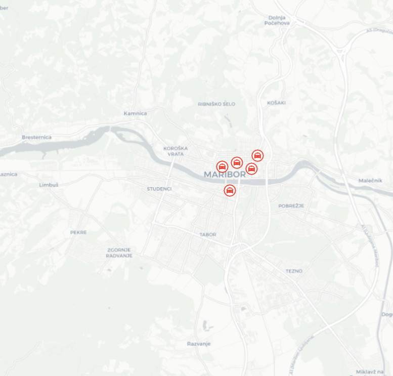
Taxi stand locations
Taxi stops are reserved parking areas intended for stopping or parking taxis during taxi services. Taxi stops are marked with prescribed traffic signals (traffic signs and floor markings).
|
|
Citation proposal
. Taxi stand locations. https://eprostor.gov.si/imps/srv/api/records/6d766774-7d80-48f4-82ca-174a6b0f1082 |
- Identification
- Distribution
- Quality
- Spatial rep.
- Ref. system
- Content
- Portrayal
- Metadata
- Md. constraints
- Md. maintenance
- Schema info
Identification
Data identification
Citation
- Date ( Revision )
- 2021-05-03T00:00:00
- Date ( Creation )
- 2021-05-03T00:00:00
- Identifier
-
SI.OB_70.TAKSI
/
6d766774-7d80-48f4-82ca-174a6b0f1082
Distributor
Maintenance information
- Maintenance and update frequency
- As needed
- Maintenance note
- Podatki se posodobijo ob spremembah, ki se odražajo v atributih podatkov ali v geometriji podatkov.
- Keywords
-
- Pitniki
- GEMET - INSPIRE themes, version 1.0 GEMET - INSPIRE themes, version 1.0 ( Theme )
-
- Utility and governmental services
- Keywords
-
- Prometna infrastruktura javnega potniškega prometa
- Keywords
-
- Mobilnost
- Keywords
-
- Taksi
- Keywords
-
- Postajališča
- Use constraints
- Other restrictions
Legal constraints
- Use constraints
- Other restrictions
- Use limitation
- Splošni pogoji uporabe podatkov: https://prostor.maribor.si/geonetwork/srv/slv/catalog.search#/metadata/3522a982-3519-4abf-aa51-60f975701b46
Legal constraints
- Access constraints
- Other restrictions
- Use limitation
- No limitations
- Spatial representation type
- Vector
- Denominator
- 1000
- Metadata language
- Slovenian
- Character set
- UTF8
- Topic category
-
- Utilities communication
N
S
E
W
))
Distribution
Distribution
- Distribution format
-
-
ESRI Shapefile
(3.2.1 )
- Specification
-
ESRI Shapefile
(3.2.1 )
- OnLine resource
- int_mob_taksi_postaje
Quality
Data quality
- Hierarchy level
- Dataset
Conformance result
Citation
- Date ( Publication )
- 2010-12-08
Identifier
- Projection
- Codespace
- EU
- Explanation
- See the referenced specification
- Pass
- false
Quantitative result
- Value
- 0
- Statement
- Not known.
Ref. system
- Reference system identifier
- http://www.opengis.net/def/crs/EPSG/0/3794
Metadata
Metadata
- File identifier
- 6d766774-7d80-48f4-82ca-174a6b0f1082 XML
- Metadata language
- Slovenian
- Character set
- MD_CharacterSetCode_utf8
- Hierarchy level
- Dataset
- Date stamp
- 2021-12-01T14:34:36
- Metadata standard name
- ISO 19115:2003/19139
- Metadata standard version
- 1.0
Point of contact
Md. maintenance
- Maintenance and update frequency
- As needed
Overviews

Provided by

Views
6d766774-7d80-48f4-82ca-174a6b0f1082
Access to the portal
Read here the full details and access to the data.
Associated resources
Not available
 Slovenski INSPIRE metapodatkovni sistem