 Slovenski INSPIRE metapodatkovni sistem
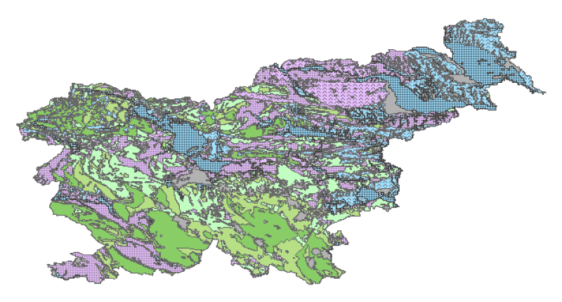
Hydrogeological map (LAWA) of Slovenia 1:250.000
Hydrogeological map of Slovenia 1:250.000 represent hydrogeological characteristics of overlaying strata. The identification and classification of strata is based on LAWA classification. Hydrogeological units of LAWA classification are defined on type of porosity and basic petrographical composition. Geological strata with kartic porosity were additionaly classified after karstification stage.
|
|
Citation proposal
Geological Survey of Slovenia Geološki zavod Slovenije - Geološki zavod Slovenije (2008) . Hydrogeological map (LAWA) of Slovenia 1:250.000. https://eprostor.gov.si/imps/srv/api/records/6f6a5f98-b84d-431b-b465-925938e68f34 |
Simple
- Alternate title
- Hydrogeological map of Slovenia
- Alternate title
- HGK - LAWA of Slovenia
- Date ( Creation )
- 2008-06-01
- Date ( Publication )
- 2008-06-01
- Date ( Revision )
- 2008-06-01
- Identifier
- SI.GEOZS.HIDRO.HGK.LAWA / 976b340d-954c-4832-870a-fd7fae11c4aa
- Purpose
- The main objective of the map is the identification and characterization of groundwater bodies on the national scale (level). Also offers support for groundwater resources management and protection.
Author
Point of contact
Geological Survey of Slovenia
-
Petra Meglič
Jasna Šinigoj
Dimičeva ulica 14
Ljubljana
1000
Slovenija
- Website
- http://www.geo-zs.si
Custodian
- Maintenance and update frequency
- As needed
- Keywords ( Theme )
-
- aquifer
- aquifer type
- type of porosity
- petrographical composition
- eWater
- Keywords ( Discipline )
-
- hydrogeology
- hydrogeological map of Slovenia
- Keywords ( Place )
-
- Slovenia
- Keywords ( Theme )
-
- INSPIRE
- GEMET - INSPIRE themes, version 1.0 GEMET - INSPIRE themes, version 1.0 ( Theme )
-
- Geologija
- Spatial scope ( Theme )
-
- National
- Use limitation
- Data is available under a Creative Commons - Attribution 4.0 International (CC BY 4.0) license. (https://creativecommons.org/licenses/by/4.0)
- Access constraints
- Copyright
- Access constraints
- Other restrictions
- Use constraints
- Copyright
- Use limitation
- Data is available under a Creative Commons - Attribution 4.0 International (CC BY 4.0) license. (https://creativecommons.org/licenses/by/4.0)
- Spatial representation type
- Vector
- Distance
- 250 m
- Denominator
- 250000
- Metadata language
- English
- Character set
- UTF8
- Topic category
-
- Geoscientific information
N
S
E
W
))
- Reference system identifier
- EPSG / MGI / Slovene National Grid (EPSG:3912) / 7.4
- Reference system identifier
- EPSG / WGS 84 (EPSG:4326) / 7.4
- Reference system identifier
- EPSG / Slovenia 1996 / Slovene National Grid (EPSG:3794) / 7.4
- Distribution format
-
- WMS (1.1.3 )
- OnLine resource
- Hgk_lawa_ew_wgs
- OnLine resource
-
Hgk_lawa_ew_wgs.zip
shapefile
- Hierarchy level
- Dataset
Conformance result
- Date ( Publication )
- 2010-12-08
- Explanation
- See the referenced specification
- Statement
-
source: Geological map of Slovenia 1:250.000 (Buser, 2009);
Hydrogeological map of Slovenia, scale of source: 1:250.000, date of source: 2004, date of data acquisition: 2003, date of last renewal: 2008
- Description
- Denominator
- 250000
gmd:MD_Metadata
- File identifier
- 6f6a5f98-b84d-431b-b465-925938e68f34 XML
- Metadata language
- English
- Character set
- UTF8
- Hierarchy level
- Dataset
- Date stamp
- 2023-02-03T06:48:05
- Metadata standard name
- ISO 19115:2003/19139
- Metadata standard version
- 1.0
Point of contact
+386 1 280 97 53
- Website
-
The main purpose of the Geological Survey of Slovenia is to provide geological expertise and information about the geology of Slovenia. Geological data are fundamental for decision making in fields such as: protection of human health and the environment, drinking water supply, geohazard mitigation, urban planning, mineral resources exploration and exploitation, etc.
The main purpose of the Geological Survey of Slovenia is to provide geological expertise and information about the geology of Slovenia. Geological data are fundamental for decision making in fields such as: protection of human health and the environment, drinking water supply, geohazard mitigation, urban planning, mineral resources exploration and exploitation, etc.
Overviews
large_thumbnail
Provided by

Views
6f6a5f98-b84d-431b-b465-925938e68f34
Access to the portal
Read here the full details and access to the data.
Associated resources
Not available