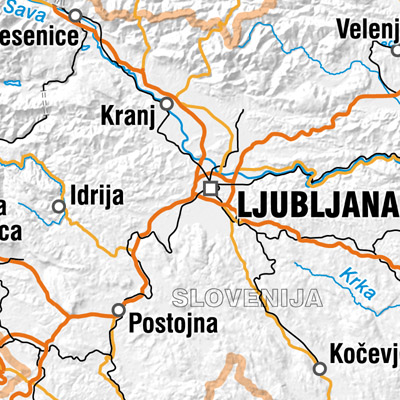
Državna pregledna karta merila 1 : 2 500 000
Državna pregledna karta merila 1 : 2 500 000 prikazuje območje celotne Slovenije in nekoliko večje območje sosednjih držav kot ostale pregledne karte. Vsebinski sloji: naselja in objekti, komunikacije, hidrografija, meje in ločnice ter zemljepisna imena. Podatkovni niz se uporablja za "grobo" orientacijo v prostoru ter za potrebe preglednih in tematskih prikazov.
|
|
Citation proposal
Geodetska uprava Republike Slovenije (2022) . Državna pregledna karta merila 1 : 2 500 000. https://eprostor.gov.si/imps/srv/api/records/8d3cd92e-ad15-4069-9225-3047e35deafa |
INSPIRE
Identification
- File identifier
- 8d3cd92e-ad15-4069-9225-3047e35deafa XML
- Hierarchy level
- Dataset
- OnLine resource
- Portal Prostor
- OnLine resource
- Aplikacija JGP za prenos podatkov
- Identifier
- SI.GURS.DPK2500 / 3985e88c-d1f7-11ec-9d64-0242ac120002
- Metadata language
- Slovenian
- Reference system identifier
- http://www.opengis.net/def/crs/EPSG/0/3794
Classification of data and services
- Topic category
-
- Location
- Imagery base maps earth cover
Classification of data and services
Coupled resource
Coupled resource
Classification of data and services
Coupled resource
Coupled resource
Keywords
- GEMET - INSPIRE themes, version 1.0 ( Theme )
-
- Prometna omrežja
- Zemljepisna imena
- Hidrografija
Other keywords
- Keywords
-
- Pregledna karta
Geographic coverage
N
S
E
W
))
Temporal reference
Temporal extent
Temporal extent
- Date ( Publication )
- 2022-05-01
- Date ( Revision )
- 2023-12-31
- Date ( Creation )
- 2022-05-01
Quality and validity
- Lineage
- Vir: državna pregledna karta merila 1 : 1 000 000 (DPK 1000). Državna pregledna karta merila 1 : 2 500 000 je bila prvič izdelana leta 2021, predvidena obnova je na 2 leti. Horizontalni geodetski datum je Geodetski datum 1996 z oznako D96. Pokrito je celotno območje Slovenije. Pozicijska natančnost je enakovredna pozicijski natančnosti državne pregledne karte v merilu 1 : 1 000 000, zmanjšane zaradi generalizacije.
Spatial resolution
Spatial resolution (scale)
- Denominator
- 2500000
Spatial resolution (distance)
Md. maintenance
- Maintenance and update frequency
- Annually
- Maintenance note
- Možno, da bo vzdrževanje na 2 leti.
Coordinate Reference System
Encoding
- Format
- TIFF
- Version
- 6.0
- Specification
- Character set
- 8859 Part 2
- Spatial representation type
- Grid
Conformity
Conformance result
- Date ( Publication )
- 2010-12-08
- Projection
- Codespace
- EU
- Explanation
- Glej referenčno specifikacijo
- Pass
- true
Conformity
Conformance result
- Date ( Publication )
- 2010-12-08
- Projection
- Codespace
- EU
- Explanation
- Glej referenčno specifikacijo
- Pass
- true
constraintsRelatedToAccessAndUse
Use limitation
useConstraint
Access constraints
Access constraints
constraintsRelatedToAccessAndUse
Use limitation
- Use limitation
- Splošni pogoji uporabe geodetskih podatkov: https://www.e-prostor.gov.si/dostopi/javni-dostop/?acitem=1821-1822
Access constraints
Access constraints
Responsible organization (s)
Custodian
Distributor
Responsible organization (s)
Custodian
Distributor
Metadata information
Point of contact
- Date stamp
- 2024-04-17T08:40:40
SDS
Conformance class 1: invocable
Access Point URL
Endpoint URL
Technical specification
Conformance class 2: interoperable
Coordinate reference system
Quality of Service
Access constraints
Limitation
Use constraints
Limitation
Responsible custodian
Contact for the resource
Conformance class 3: harmonized
Overviews

Provided by

Views
8d3cd92e-ad15-4069-9225-3047e35deafa
Access to the portal
Read here the full details and access to the data.
Associated resources
Not available
 Slovenski INSPIRE metapodatkovni sistem