 Slovenski INSPIRE metapodatkovni sistem
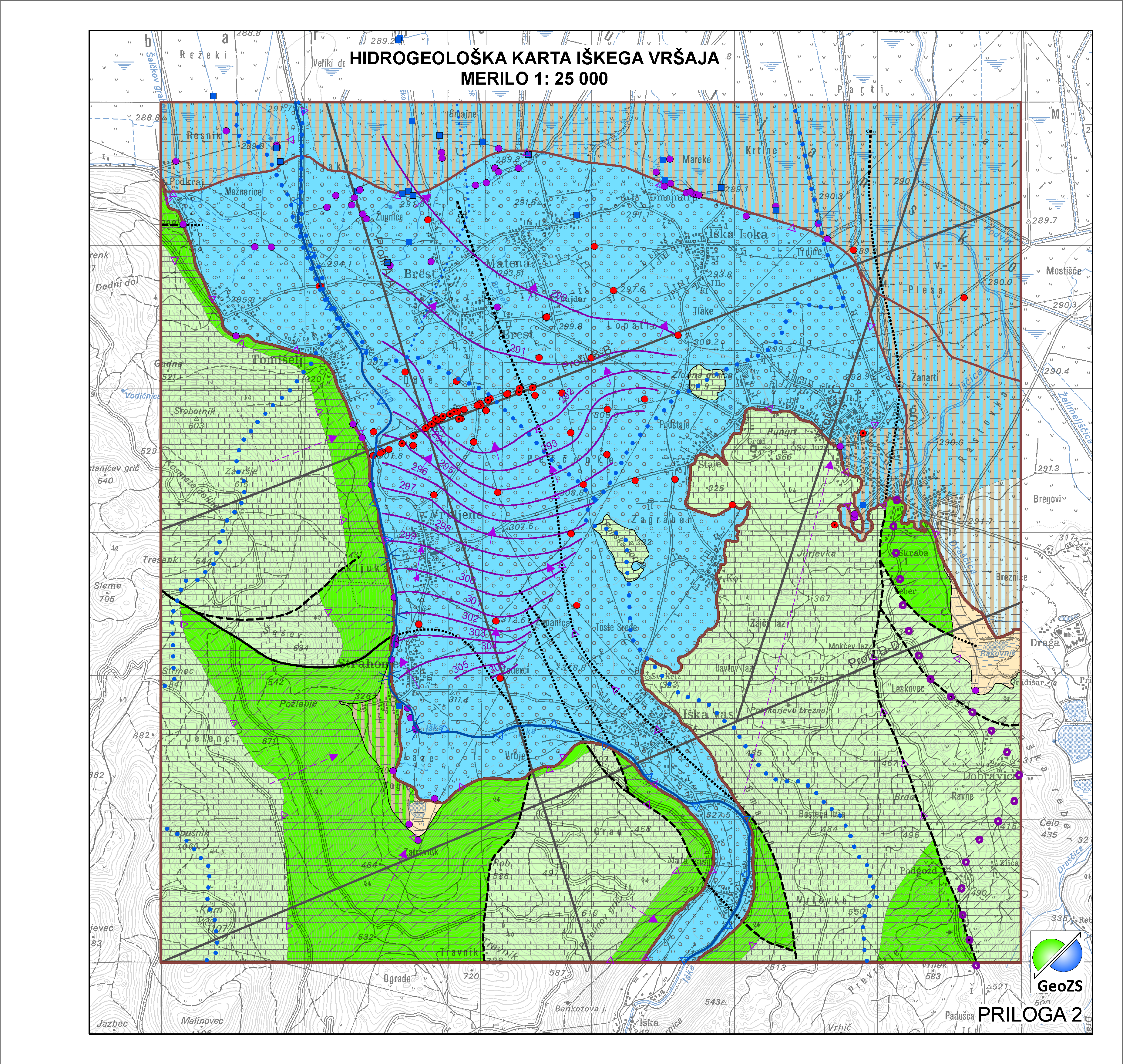
Hydrogeological map of Iška alluvial fan 1:25 000 - Aquifer Systems
Vodonosni sistem je ozemlje z geološko zgradbo, v kateri nastopata vsaj dva različna vodonosnika, z ali brez medsebojne hidravlične povezave. Na obravnavanem območju so bile meje vodonosnih sistemov prilagojene na merilo karte 1:25.000. Namenjena so zanesljivemu ugotavljanju stanja celotne pomembne prostornine podzemnih voda v državi in doseganja okoljskih ciljev, ki jih predpisuje Vodna direktiva.
|
|
Citation proposal
Geološki zavod Slovenije Geological Survey of Slovenia - Geološki zavod Slovenije (2015) . Hydrogeological map of Iška alluvial fan 1:25 000 - Aquifer Systems. https://eprostor.gov.si/imps/srv/api/records/ae24ad88-9b0b-4aa7-b248-df670e2b92d1 |
Simple
- Alternate title
- Hydrogeological map of Iška alluvial fan 1:25 000
- Alternate title
- Aquifer Systems
- Date ( Creation )
- 2014-11-18
- Date ( Publication )
- 2015-01-01
- Identifier
- SI.GEOZS.HG25.HGSIS / aaf2a92e-9957-43e6-b7ac-71b2ebe918e2
- Presentation form
- Digital map
- Purpose
- Namenjena so zanesljivemu ugotavljanju stanja celotne pomembne prostornine podzemnih voda v državi in doseganja okoljskih ciljev, ki jih predpisuje Vodna direktiva.
Author
Point of contact
Geological Survey of Slovenia
-
dr. Nina Mali
Nina Mali, PhD
(Head of Groundwater-Hydrogeology Department )
Dimičeva ulica 14
Ljubljana
1000
Slovenija
Custodian
- Maintenance and update frequency
- As needed
- Keywords ( Discipline )
-
- hydrogeology
- geology
- Keywords ( Place )
-
- aquifer system
- groundwater body
- aquifer type
- Iška alluvial fan
- hydrogeological map
- Keywords ( Place )
-
- Ig
- Slovenia
- Keywords ( Theme )
-
- INSPIRE
- GEMET - INSPIRE themes, version 1.0 GEMET - INSPIRE themes, version 1.0 ( Theme )
-
- Geology
- Spatial scope ( Theme )
-
- Local
- Access constraints
- Copyright
- Use limitation
- Hidrogeološka karta Iškega vršaja v merilu 1:25000. Hidrogeološka karta še ni v uporabi "OSNUTEK"
- Use limitation
- Data is available under a Creative Commons - Attribution 4.0 International (CC BY 4.0) license. (https://creativecommons.org/licenses/by/4.0)
- Use limitation
- Hidrogeološka karta še ni v uporabi "OSNUTEK"
- Use limitation
- Data is available under a Creative Commons - Attribution 4.0 International (CC BY 4.0) license. (https://creativecommons.org/licenses/by/4.0)
- Spatial representation type
- Vector
- Denominator
- 25000
- Metadata language
- Slovenian
- Metadata language
- English
- Character set
- UTF8
- Topic category
-
- Geoscientific information
- Environment description
- ArcGIS 10.1
- Description
- Slovenia
N
S
E
W
))
- Begin date
- 2014-06-01
- End date
- 2014-12-31
- Supplemental Information
- Reference system identifier
- EPSG / MGI / Slovene National Grid (EPSG:3787) / 7.4
- Reference system identifier
- EPSG / WGS 84 (EPSG:4326) / 7.4
- Reference system identifier
- EPSG / Slovenia 1996 / Slovene National Grid (EPSG:3794) / 7.4
- Reference system identifier
- http://www.opengis.net/def/crs/EPSG/0/4258
- Topology level
- Geometry only
- Hierarchy level
- Dataset
Conformance result
- Date ( Publication )
- 2010-12-08
- Explanation
- Podatek je v skladu z INSPIRE za Geologijo
- Pass
- true
- Statement
- Na obravnavanem območju so bile meje vodonosnih sistemov prilagojene na merilo karte 1:25.000.
- Description
- Vodonosni sistemi
gmd:MD_Metadata
- File identifier
- ae24ad88-9b0b-4aa7-b248-df670e2b92d1 XML
- Metadata language
- Slovenian
- Character set
- UTF8
- Hierarchy level
- Dataset
- Date stamp
- 2021-05-06T15:58:24
- Metadata standard name
- ISO 19115:2003/19139
- Metadata standard version
- 1.0
Point of contact
Geological Survey of Slovenia
-
Matija Krivic
Matija Krivic
Dimičeva ulica 14
Ljubljana
1000
Slovenija
+386 1 280 97 53
- Website
-
The main purpose of the Geological Survey of Slovenia is to provide geological expertise and information about the geology of Slovenia. Geological data are fundamental for decision making in fields such as: protection of human health and the environment, drinking water supply, geohazard mitigation, urban planning, mineral resources exploration and exploitation, etc.
The main purpose of the Geological Survey of Slovenia is to provide geological expertise and information about the geology of Slovenia. Geological data are fundamental for decision making in fields such as: protection of human health and the environment, drinking water supply, geohazard mitigation, urban planning, mineral resources exploration and exploitation, etc.
- Dataset URI
Overviews
large_thumbnail
Provided by

Views
ae24ad88-9b0b-4aa7-b248-df670e2b92d1
Access to the portal
Read here the full details and access to the data.
Associated resources
Not available