 Slovenski INSPIRE metapodatkovni sistem
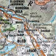
National General Map at 1 : 250 000 Scale
The National General Map at 1: 250 000 Scale shows the entire territory of Slovenia on one sheet of A0 format. Layers: mathematical elements, settlements and objects, communications, relief, hydrography, land cover, boundaries and dividing line, geographical names. The map is also available in printed form. The data set is used for "rough" orientation in the space and for the needs of large scale and thematic displaying.
|
|
Citation proposal
Geodetska uprava Republike Slovenije Geodetska uprava Republike Slovenije Surveying and Mapping Authority of the Republic of Slovenia . National General Map at 1 : 250 000 Scale. https://eprostor.gov.si/imps/srv/api/records/ba24b3a3-c626-4352-86bc-23e1a9679dae |
Simple
- Date ( Creation )
- 2008-12-31
- Date ( Revision )
- 2023-12-31
- Identifier
- SI.GURS.DPK250 / a82e8d11-6575-46af-838c-2e0ed4fb5d7d
- Keywords
-
- Mathematical elements, settlements and objects, communications, relief, hydrography, land cover, boundaries and dividing line, geographical names, traffic network, imagery/base maps/land cover
- GEMET - INSPIRE themes, version 1.0 GEMET - INSPIRE themes, version 1.0 ( Theme )
-
- Hydrography
- Transport networks
- Land cover
- Use constraints
- Other restrictions
- Use limitation
- Splošni pogoji uporabe geodetskih podatkov: https://www.e-prostor.gov.si/dostopi/javni-dostop/?acitem=1821-1822
- Access constraints
- Other restrictions
- Use limitation
- No limitations
- Denominator
- 250000
- Metadata language
- Slovenian
- Topic category
-
- Imagery base maps earth cover
N
S
E
W
))
- Reference system identifier
- http://www.opengis.net/def/crs/EPSG/0/3794 / http://www.opengis.net/def/crs/EPSG/0/3794 /
- Distribution format
-
-
TIFF
( )
- Specification
-
TIFF
( )
- OnLine resource
- Spatial Portal
- OnLine resource
- Application Public Geodetic Data
- OnLine resource
- Application Public Geodetic Viewer
- Hierarchy level
- Dataset
Conformance result
- Date ( Publication )
- 2014-04-11
- Identifier
- SOP / 2014-01-0962
- Explanation
- Glej referenčno specifikacijo
- Pass
- true
- Statement
-
Source: reproduction originals of Topographic Maps at 1 : 200 000 Scale (VGI).
The National General Map at 1 : 250 000 Scale was made in 2008, the regular maintenance cycle is 2 years. National coordinate system D48, Gauß-Krügerjev projection. The whole territory of Slovenia is covered. The assessment of position accuracy is 120 m.
Data quality info
No information provided.
gmd:MD_Metadata
- File identifier
- ba24b3a3-c626-4352-86bc-23e1a9679dae XML
- Metadata language
- Slovenian
- Hierarchy level
- Dataset
- Date stamp
- 2024-04-09T08:59:04
- Metadata standard name
- ISO 19115:2003/19139
- Metadata standard version
- 1.0
Overviews
thumbnail

large_thumbnail
Provided by

Views
ba24b3a3-c626-4352-86bc-23e1a9679dae
Access to the portal
Read here the full details and access to the data.
Associated resources
Not available