 Slovenski INSPIRE metapodatkovni sistem
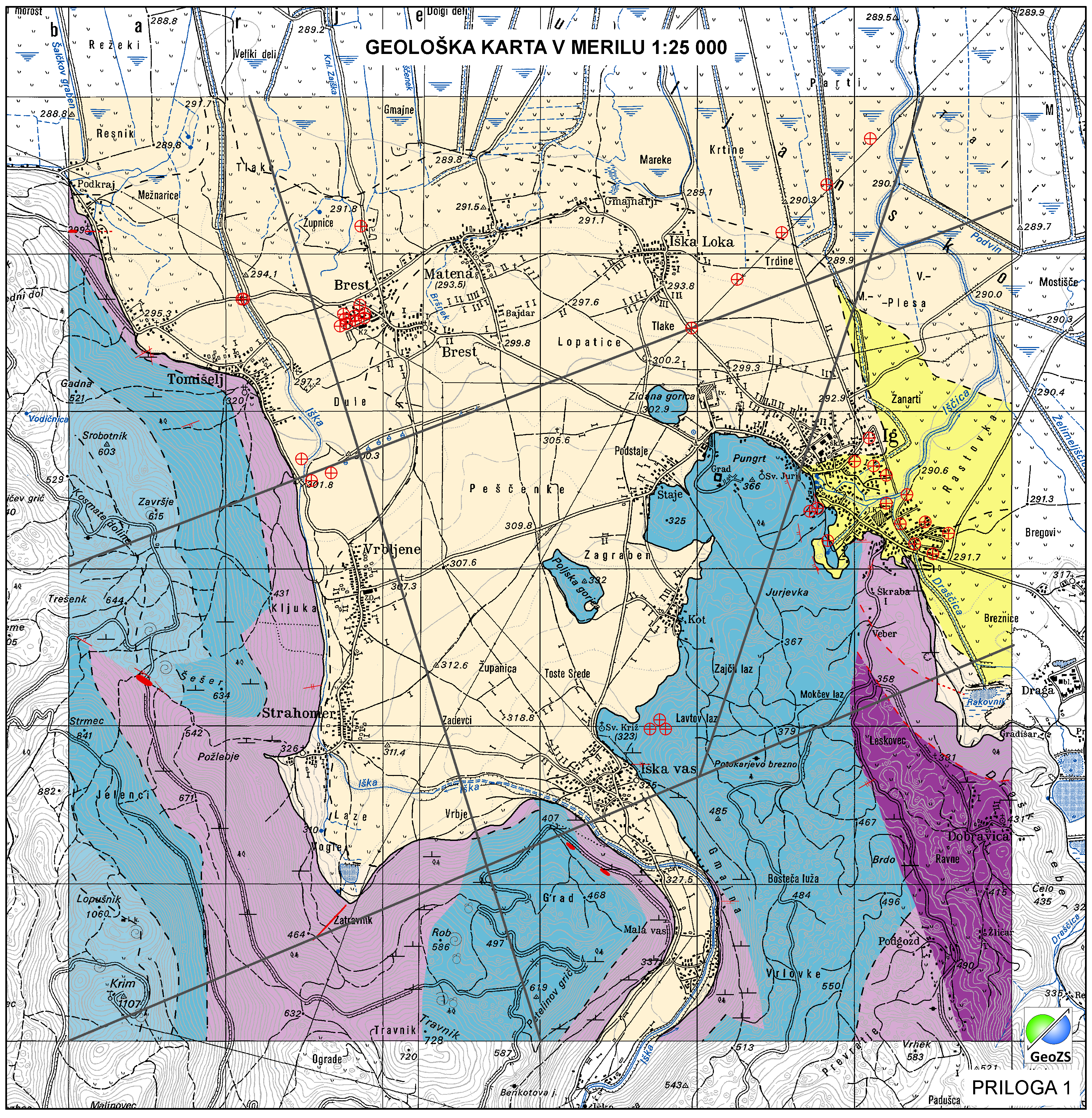
Geological map of Iška alluvial fan 1:25 000 - Boreholes
Layer Boreholes shows the localities where structural boreholes were drilled.
|
|
Citation proposal
Geološki zavod Slovenije Geological Survey of Slovenia - Geološki zavod Slovenije (2014) . Geological map of Iška alluvial fan 1:25 000 - Boreholes. https://eprostor.gov.si/imps/srv/api/records/ccbd1d59-ad73-4866-af68-e7497ddb8b9c |
Simple
- Alternate title
- Geological map of Iška alluvial fan 1:25 000
- Alternate title
- Boreholes
- Date ( Creation )
- 2014-11-18
- Date ( Publication )
- 2014-11-28
- Identifier
- SI.GEOZS.GE25.VRTINE / 154d1a82-9bea-4a5f-82f3-c732fe4654ef
- Presentation form
- Digital map
- Purpose
- Displaying boreholes.
Author
Point of contact
Geological Survey of Slovenia
-
dr. Matevž Novak
Matevž Novak, PhD
Dimičeva ulica 14
Ljubljana
1000
Slovenija
Custodian
- Maintenance and update frequency
- As needed
- Keywords ( Discipline )
-
- geology
- hydrogeology
- Regional geology
- Keywords ( Theme )
-
- geology
- lithostratigraphy
- geologic structure
- boreholes
- Keywords ( Place )
-
- Iška alluvial fan
- Slovenia
- Ig
- Keywords ( Theme )
-
- INSPIRE
- GEMET - INSPIRE themes, version 1.0 GEMET - INSPIRE themes, version 1.0 ( Theme )
-
- Geology
- Spatial scope ( Theme )
-
- Local
- Use limitation
- Data is available under a Creative Commons - Attribution 4.0 International (CC BY 4.0) license. (https://creativecommons.org/licenses/by/4.0)
- Access constraints
- Copyright
- Use limitation
- Geological map of Iška alluvial fan in scale of 1:25000. Geological map not in use "DRAFT"
- Use limitation
- Geological map not in use "DRAFT"
- Use limitation
- Data is available under a Creative Commons - Attribution 4.0 International (CC BY 4.0) license. (https://creativecommons.org/licenses/by/4.0)
- Spatial representation type
- Vector
- Denominator
- 25000
- Metadata language
- Slovenian
- Metadata language
- English
- Character set
- UTF8
- Topic category
-
- Geoscientific information
- Environment description
- ArcGIS 10.1
- Description
- Slovenia
N
S
E
W
))
- Begin date
- 2014-06-01
- End date
- 2014-12-31
- Supplemental Information
- Reference system identifier
- EPSG / MGI / Slovene National Grid (EPSG:3787) / 7.4
- Reference system identifier
- EPSG / WGS 84 (EPSG:4326) / 7.4
- Reference system identifier
- EPSG / Slovenia 1996 / Slovene National Grid (EPSG:3794) / 7.4
- Reference system identifier
- http://www.opengis.net/def/crs/EPSG/0/4258
- Topology level
- Geometry only
- Hierarchy level
- Dataset
Conformance result
- Date ( Publication )
- 2010-12-08
- Explanation
- Podatek je v skladu z INSPIRE za Geologijo
- Pass
- true
- Statement
- Boreholes
- Description
- Boreholes
gmd:MD_Metadata
- File identifier
- ccbd1d59-ad73-4866-af68-e7497ddb8b9c XML
- Metadata language
- Slovenian
- Character set
- UTF8
- Hierarchy level
- Dataset
- Date stamp
- 2021-11-10T11:11:16
- Metadata standard name
- ISO 19115:2003/19139
- Metadata standard version
- 1.0
Point of contact
Geological Survey of Slovenia
-
Blaž Milanič
Blaž Milanič
Dimičeva ulica 14
Ljubljana
1000
Slovenija
(01) 28 09 753
- Website
-
The main purpose of the Geological Survey of Slovenia is to provide geological expertise and information about the geology of Slovenia. Geological data are fundamental for decision making in fields such as: protection of human health and the environment, drinking water supply, geohazard mitigation, urban planning, mineral resources exploration and exploitation, etc.
The main purpose of the Geological Survey of Slovenia is to provide geological expertise and information about the geology of Slovenia. Geological data are fundamental for decision making in fields such as: protection of human health and the environment, drinking water supply, geohazard mitigation, urban planning, mineral resources exploration and exploitation, etc.
- Dataset URI
Overviews
large_thumbnail
Provided by

Views
ccbd1d59-ad73-4866-af68-e7497ddb8b9c
Access to the portal
Read here the full details and access to the data.
Associated resources
Not available