 Slovenski INSPIRE metapodatkovni sistem
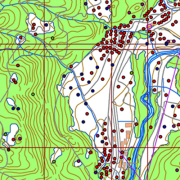
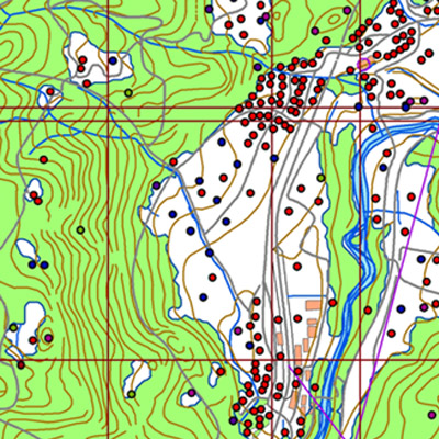
National Topographic Map at 1 : 50 000 scale - vector data
A brief description:
National Topographic Map at 1 : 50 000 scale - vector data (DTK 50V) is an object-oriented cartographic database (vector elements).
The objects are categorized into eight object groups:
- mathematical elements
- settlements and facilities
- communications
- relief
- hydrography
- land cover
- boundaries and dividing lines
- geographical names.
DTK 50V is from 2017 available also as a seamless vector cartographic set of data, which is maintained as SHP files (46). SHP files are also available for the users.
The data of the vector DTK 50 are used for spatial planning, for field orientation purposes, as a basis for other topics and as a source for the production of different maps.
|
|
Citation proposal
Geodetska uprava Republike Slovenije Geodetska uprava Republike Slovenije Surveying and Mapping Authority of the Republic of Slovenia . National Topographic Map at 1 : 50 000 scale - vector data. https://eprostor.gov.si/imps/srv/api/records/ccfeed94-651d-4742-b5b0-ae5a248ea2ca |
Simple
- Date ( Creation )
- 2016-12-31
- Date ( Revision )
- 2025-12-31
- Identifier
- SI.GURS.DTK50V / b61d22c6-3df3-433a-be16-b9003d7807a9
- Keywords
-
- mathematical elements, settlements and objects, communications, relief, hydrography, land cover, borders, geographical names, images/base maps/land cover
- GEMET - INSPIRE themes, version 1.0 GEMET - INSPIRE themes, version 1.0 ( Theme )
-
- Land cover
- Hydrography
- Transport networks
- Use constraints
- Other restrictions
- Use limitation
- Splošni pogoji uporabe geodetskih podatkov: https://www.e-prostor.gov.si/dostopi/javni-dostop/?acitem=1821-1822
- Access constraints
- Other restrictions
- Use limitation
- No limitations
- Denominator
- 50000
- Metadata language
- Slovenian
- Topic category
-
- Imagery base maps earth cover
))
- Reference system identifier
- http://www.opengis.net/def/crs/EPSG/0/3794 / http://www.opengis.net/def/crs/EPSG/0/3794 /
- Distribution format
-
-
ESRI Shapefile
(1.0 )
- Specification
-
ESRI Shapefile
(1.0 )
- OnLine resource
- Spatial Portal
- OnLine resource
- Application Public Geodetic Data
- Hierarchy level
- Dataset
Conformance result
- Date ( Publication )
- 2010-12-08
- Explanation
- See the referenced specification
Conformance result
- Date ( Publication )
- 2014-04-11
- Identifier
- SOP / 2014-01-0962
- Explanation
- Glej referenčno specifikacijo
- Pass
- true
- Statement
-
Sources for the establishment of DTK 50V: topographic map at 1 : 50 000 scale (made at VGI), data of cyclical aerial survey of Slovenia, field survey. The map was made between 1999 and 2005. The renewal is being in process from 2006. For the renewal, data of cyclical aerial survey, lidar data, field data survey and other relevant available data are used. National coordinate system D48, Gauß-Krüger projection. New national coordinate system D96, transverse Mercator projection (TM).
The data set covers whole country. The positioning accuracy is 20 m.
gmd:MD_Metadata
- File identifier
- ccfeed94-651d-4742-b5b0-ae5a248ea2ca XML
- Metadata language
- Slovenian
- Parent identifier
- ee5819e6-425c-4408-831a-ee60a729f2a1
- Hierarchy level
- Dataset
- Date stamp
- 2026-02-06T08:23:26
- Metadata standard name
- ISO 19115:2003/19139
- Metadata standard version
- 1.0
Overviews
Provided by
