 Slovenski INSPIRE metapodatkovni sistem
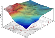
Digital Geoid Models of Slovenia
The dataset of the national digital geoid models of Slovenia includes data for:
- the Slovenian absolute geoid model from the year 2000 (Slovenian SLOvenski Absolutni Model Geoida 2000) – SLOAMG2000 and
- the Slovenian height reference surface from the year 2016 (SLOvenska Višinska Referenčna Ploskev 2016) – SLO-VRP2016/Koper.
The models enable transformations between the ellipsoidal heights above the GRS80 ellipsoid in the geodetic datum D96 (ETRS89/D96) and the national height reference systems of:
- normal orthometric heights in the height datum Trst – SVS2000/Trst and
- normal heights in the height datum Koper – SVS2010/Koper.
SLOAMG2000 is a hybrid geoid model (astrogravimetric model) computed by least-squares collocation in the framework of a remove-restore procedure with the use of global geopotential model EGM96. Its resolution is 1ʹ × 1,5ʹ and covers 13,25° < λ < 16,75° and 45,25° < φ < 47,00°. The average geoid undulation is 46,453 m.
SLO-VRP2016/Koper is a hybrid quasi-geoid model. It is based on Stokes/Molodensky equations, the Fast Fourier Transform technique, and the use of global geopotential model EGM08. Its resolution is 30ʺ × 45ʺ and covers 13° < λ < 17° and 45° < φ < 47°. The average geoid undulation is 46,162 m. The outer accuracy (based on 871 control GNSS/levelling measurements along levelling lines) is up to 10 cm.
The data in this dataset are available in GRI (Gravsoft), GRD (Surfer Grid), and XYZ formats, and – on the ISG (International Service for the Geoid) web page – also in the ISG format.
|
|
Citation proposal
Geodetska uprava Republike Slovenije Geodetska uprava Republike Slovenije Surveying and Mapping Authority of the Republic of Slovenia (2000) . Digital Geoid Models of Slovenia. https://eprostor.gov.si/imps/srv/api/records/ce3aa31f-d6df-4976-abf0-31cb3b084a72 |
INSPIRE
Identification
- File identifier
- ce3aa31f-d6df-4976-abf0-31cb3b084a72 XML
- Hierarchy level
- Dataset
- OnLine resource
- Spatial Portal
- OnLine resource
- Application Public Geodetic Data
- Identifier
- SI.GURS.DMG / f0b80c1a-7832-4a17-b7b0-79dd8a491f74
- Metadata language
- Slovenian
- Reference system identifier
- http://www.opengis.net/def/crs/EPSG/0/3794 / http://www.opengis.net/def/crs/EPSG/0/3794 /
Classification of data and services
- Topic category
-
- Elevation
Classification of data and services
Coupled resource
Coupled resource
Classification of data and services
Coupled resource
Coupled resource
Keywords
- GEMET - INSPIRE themes, version 1.0 GEMET - INSPIRE themes, version 1.0 ( Theme )
-
- Coordinate reference systems
Other keywords
- Keywords
-
- Digital geoid model, geoid undulation
Geographic coverage
))
Temporal reference
Temporal extent
Temporal extent
- Date ( Creation )
- 2000-05-21
- Date ( Publication )
- 2000-05-21
- Date ( Revision )
- 2000-05-21
Quality and validity
- Lineage
-
The solution is given in the correct network (grid) 1.0' x 1.5', which in nature represents a square with a side 1 850 m.
Calculation with a combined solution is used by the following data:
- global geopotencial model EGM96
- digital relief model (detail 11.25'' x 18.75'' or rough 90'' x 150'')
- digital density model (detail 11.25'' x 18.75'' or rough 90'' x 150'')
- 99 points with measured values of vertical deflections
- 4 605 points of gravity anomalies
- 163 GPS/levelled points
Spatial resolution
Spatial resolution (scale)
Spatial resolution (distance)
- Distance
- 1 m
Md. maintenance
Coordinate Reference System
Encoding
- Format
- grd, csv, prn
- Version
- unknown
- Specification
Conformity
Conformance result
- Date ( Publication )
- 2014-04-11
- Identifier
- SOP / 2014-01-0962
- Explanation
- Glej referenčno specifikacijo
- Pass
- true
Conformity
Conformance result
- Date ( Publication )
- 2014-04-11
- Identifier
- SOP / 2014-01-0962
- Explanation
- Glej referenčno specifikacijo
- Pass
- true
constraintsRelatedToAccessAndUse
Use limitation
useConstraint
Access constraints
Access constraints
constraintsRelatedToAccessAndUse
Use limitation
- Use limitation
- Splošni pogoji uporabe geodetskih podatkov: https://www.e-prostor.gov.si/dostopi/javni-dostop/?acitem=1821-1822
Access constraints
Access constraints
Responsible organization (s)
Responsible organization (s)
Metadata information
Point of contact
- Date stamp
- 2025-02-20T14:06:15
SDS
Conformance class 1: invocable
Access Point URL
Endpoint URL
Technical specification
Conformance class 2: interoperable
Coordinate reference system
Quality of Service
Access constraints
Limitation
Use constraints
Limitation
Responsible custodian
Contact for the resource
Conformance class 3: harmonized
Overviews
Provided by
