 Slovenski INSPIRE metapodatkovni sistem
Dataset on the National Spatial Reference System
The dataset on the national spatial reference system (SRS) contains:
- data on the national coordinate reference systems (CRS) and height reference systems (HRS),
- data on datum transformations between different national coordinate reference systems and between different height reference systems, and
- data on hierarchical geographic coordinate grids.
The data on the national coordinate/height reference systems contain parameters defining:
- national horizontal geodetic datums, including geometrical parameters of the Earth as a planet, the coreresponding reference surface – rotational ellipsoid – and national map projection, and
- national height geodetic datum, including physical parameters of the Earth, the height reference surface – (quasi-)geoid – and types of the national height systems.
The data on datum transformations contain:
- detailed specifications on transformation models with equations and
- the corresponding sets of transformation parameters.
The data on the national CRSes, HRSes and datum transformations are also supported by the internationally standardized descriptions with unique codes within the EPSG Geodetic Parameter Dataset.
Geographical coordinate grids are also available as graphical layers in the Shape format (SHP-files).
|
|
Citation proposal
Geodetska uprava Republike Slovenije Geodetska uprava Republike Slovenije Surveying and Mapping Authority of the Republic of Slovenia . Dataset on the National Spatial Reference System. https://eprostor.gov.si/imps/srv/api/records/f89273be-8d5d-4d18-83c4-c8510ba1d4e0 |
- Identification
- Distribution
- Quality
- Spatial rep.
- Ref. system
- Content
- Portrayal
- Metadata
- Md. constraints
- Md. maintenance
- Schema info
Identification
Data identification
Citation
- Date ( Creation )
- 2014-04-26
- Identifier
- SI.GURS.ZPDPKS / 02cefc84-c9eb-11e7-abc4-cec278b6b50a
Maintenance information
- Maintenance and update frequency
- As needed
- Maintenance note
- GEMET - INSPIRE themes, version 1.0 GEMET - INSPIRE themes, version 1.0 ( Theme )
-
- Geographical grid systems
- Coordinate reference systems
- Keywords
-
- coordinate reference systems, spatial position, geographical coordinate grid
Legal constraints
- Use constraints
- Other restrictions
- Use limitation
- Splošni pogoji uporabe geodetskih podatkov: https://www.e-prostor.gov.si/dostopi/javni-dostop/?acitem=1821-1822
Legal constraints
- Access constraints
- Other restrictions
- Use limitation
- No limitations
- Spatial representation type
- Vector
- Distance
- 0.01 m
- Distance
- 1 m
- Metadata language
- Slovenian
- Character set
- 8859 Part 2
- Topic category
-
- Location
))
Distribution
Distribution
- Distribution format
-
-
Text
( )
- Specification
-
Text
( )
Digital transfer options
- OnLine resource
-
Portal Spatial
Central portal for access to reference spatial data, applications and services of the Surveying and Mapping Authority of the Republic of Slovenia.
- OnLine resource
-
Public Surveying Data (JGP)
The Public Surveying Data (JGP) application is intended for downloading free data from the Surveying and Mapping Authority from the overhauled distribution system.
Quality
Data quality
- Hierarchy level
- Dataset
Conformance result
Citation
- Date ( Publication )
- 2010-12-08
Identifier
- Projection
- Codespace
- EU
- Explanation
- See the referenced specification
- Pass
- true
Conformance result
Citation
- Date ( Publication )
- 2014-04-11
- Identifier
- SOP / 2014-01-0962
- Explanation
- Glej referenčno specifikacijo
- Pass
- true
Conformance result
Citation
- Date ( Publication )
- 2015-04-15
- Identifier
- SOP / 2015-01-1115
- Explanation
- Glej referenčno specifikacijo
- Pass
- true
- Statement
-
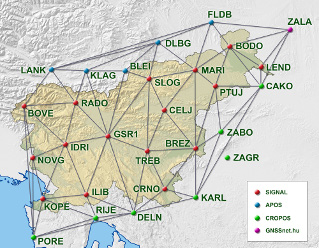
National geodetic points and GNSS stations of the national network for global positioning (SIGNAL network) represent the practical realization of the coordinate basis for all geodetic works for measurement and determination of the coordinates in Slovenia. National geodetic points are linked into geodetic networks and as such provide referential basis or geodetic datum.
A new spatial coordinate system is established in the territory of the Republic of Slovenia, determined by the article 7 of the ZDGRS and has several components: national geodetic points linked into geodetic networks, geodetic surveying and processing of surveys for coordinates determination of national geodetic points and their connection to the European coordinate system.
The status of the national geodetic point is defined by geodetic point that is materialized, means placed in nature (physically), stabilized with a permanent sign and with defined coordinates in the national spatial coordinate system. Coordinates determination of the national geodetic points requires high precision, accuracy and reliability.
Ref. system
- Reference system identifier
- http://www.opengis.net/def/crs/EPSG/0/3794
- Reference system identifier
- http://www.opengis.net/def/crs/EPSG/0/3912 / http://www.opengis.net/def/crs/EPSG/0/3912 /
Metadata
Metadata
- File identifier
- f89273be-8d5d-4d18-83c4-c8510ba1d4e0 XML
- Metadata language
- Slovenian
- Character set
- MD_CharacterSetCode_utf8
- Hierarchy level
- Dataset
- Date stamp
- 2026-07-16T12:06:00
- Metadata standard name
- ISO 19115:2003/19139
- Metadata standard version
- 1.0
Overviews

Provided by
