 Slovenski INSPIRE metapodatkovni sistem
Keyword
Coordinate reference systems
3 record(s)
Type of resources
Categories
INSPIRE themes
Keywords
Contact for the resource
Representation types
Resolution
-
The dataset on the national spatial reference system (SRS) contains: - data on the national coordinate reference systems (CRS) and height reference systems (HRS), - data on datum transformations between different national coordinate reference systems and between different height reference systems, and - data on hierarchical geographic coordinate grids. The data on the national coordinate/height reference systems contain parameters defining: - national horizontal geodetic datums, including geometrical parameters of the Earth as a planet, the coreresponding reference surface – rotational ellipsoid – and national map projection, and - national height geodetic datum, including physical parameters of the Earth, the height reference surface – (quasi-)geoid – and types of the national height systems. The data on datum transformations contain: - detailed specifications on transformation models with equations and - the corresponding sets of transformation parameters. The data on the national CRSes, HRSes and datum transformations are also supported by the internationally standardized descriptions with unique codes within the EPSG Geodetic Parameter Dataset. Geographical coordinate grids are also available as graphical layers in the Shape format (SHP-files).
-
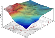
The dataset of the national digital geoid models of Slovenia includes data for: - the Slovenian absolute geoid model from the year 2000 (Slovenian SLOvenski Absolutni Model Geoida 2000) – SLOAMG2000 and - the Slovenian height reference surface from the year 2016 (SLOvenska Višinska Referenčna Ploskev 2016) – SLO-VRP2016/Koper. The models enable transformations between the ellipsoidal heights above the GRS80 ellipsoid in the geodetic datum D96 (ETRS89/D96) and the national height reference systems of: - normal orthometric heights in the height datum Trst – SVS2000/Trst and - normal heights in the height datum Koper – SVS2010/Koper. SLOAMG2000 is a hybrid geoid model (astrogravimetric model) computed by least-squares collocation in the framework of a remove-restore procedure with the use of global geopotential model EGM96. Its resolution is 1ʹ × 1,5ʹ and covers 13,25° < λ < 16,75° and 45,25° < φ < 47,00°. The average geoid undulation is 46,453 m. SLO-VRP2016/Koper is a hybrid quasi-geoid model. It is based on Stokes/Molodensky equations, the Fast Fourier Transform technique, and the use of global geopotential model EGM08. Its resolution is 30ʺ × 45ʺ and covers 13° < λ < 17° and 45° < φ < 47°. The average geoid undulation is 46,162 m. The outer accuracy (based on 871 control GNSS/levelling measurements along levelling lines) is up to 10 cm. The data in this dataset are available in GRI (Gravsoft), GRD (Surfer Grid), and XYZ formats, and – on the ISG (International Service for the Geoid) web page – also in the ISG format.
-

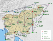
Two national CORS networks have been established in Slovenia, i.e.: - the SIGNAL Network (the abbreviation means: SlovenIa-Geodesy-NAvigation-Location) and - the Zero-Order Combined Geodetic Network. The SIGNAL Network provides data and services for the positioning in the national coordinate and height reference systems (CRS, HRS). The Zero-Order Combined Geodetic Network enables quality control of the SIGNAL Network data and services as well as the realization of the national spatial reference system (SRS) and monitoring of its quality in long term. The data provided by the national CORS networks contain GNSS observations at the permanent GNSS stations and their corrections generated by processing the data from the whole network. These data are needed for the positioning in the national CRS/HRS by applying: - kinematic GNSS positioning in real time (RTK) or - static or fast static GNSS positioning with processing of the collected observations in the office (post-processing). The data for the real-time positioning are available in the RTCM format via web connection (NTRIP protocol) or via dial-up acces (GSM) as: - RTK services for the positioning based on phase observations ( few cm accuracy) and - DGPS services for the positioning based on code observations (few dm accuracy). The GNSS observations collected for the post-processing are available in RINEX (Receiver Independent Exchange) format as: - RINEX files for the CORS network stations or - virtual RINEX files for the selected location. RINEX data can be accessed via the RINEX Portal of the Service for the GNSS. They can be ordered for a set of CORS network stations or selected locations of GNSS surveys, for the required time span and interval of registration of the GNSS signals.