 Slovenski INSPIRE metapodatkovni sistem
Keyword
Elevation
4 record(s)
Type of resources
Categories
INSPIRE themes
Keywords
Contact for the resource
Formats
Representation types
Resolution
-

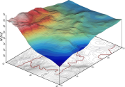
Digital Elevation Model is a description of the relief in the form of a model, where the height of the relief is given for each node of the square grid. The model represents a Digital Relief Model of Slovenia and Digital Elevation Model with grid size 5 x 5 m (DMV 5). Digital Relief Model of Slovenia was established using various geodetic data, using the method of weighted aggregation from resources with some geomorphological corrections. It was made in 2001-2005 and is available as a model in a square grid with a cell size 12.5 m, 25 m and 100 m (DMV 12.5, DMV 25 and DMV 100). DMV 5 was created in 2006 and was regularly maintained until 2014 using cyclic aerial survey of Slovenia (CAS). Some additional data sources were used to produce the model as well. The data of both models are available as ASCII files (y, x, H), for example: 401000.0 112000.0 251.71 401025.0 112000.0 241.03 401050.0 112000.0 230.51 401075.0 112000.0 219.88 401100.0 112000.0 208.31 401125.0 112000.0 195.45
-
This download service provides INSPIRE compliant data.
-
This download service provides INSPIRE compliant data.
-
The dataset of the national digital geoid models of Slovenia includes data for: - the Slovenian absolute geoid model from the year 2000 (Slovenian SLOvenski Absolutni Model Geoida 2000) – SLOAMG2000 and - the Slovenian height reference surface from the year 2016 (SLOvenska Višinska Referenčna Ploskev 2016) – SLO-VRP2016/Koper. The models enable transformations between the ellipsoidal heights above the GRS80 ellipsoid in the geodetic datum D96 (ETRS89/D96) and the national height reference systems of: - normal orthometric heights in the height datum Trst – SVS2000/Trst and - normal heights in the height datum Koper – SVS2010/Koper. SLOAMG2000 is a hybrid geoid model (astrogravimetric model) computed by least-squares collocation in the framework of a remove-restore procedure with the use of global geopotential model EGM96. Its resolution is 1ʹ × 1,5ʹ and covers 13,25° < λ < 16,75° and 45,25° < φ < 47,00°. The average geoid undulation is 46,453 m. SLO-VRP2016/Koper is a hybrid quasi-geoid model. It is based on Stokes/Molodensky equations, the Fast Fourier Transform technique, and the use of global geopotential model EGM08. Its resolution is 30ʺ × 45ʺ and covers 13° < λ < 17° and 45° < φ < 47°. The average geoid undulation is 46,162 m. The outer accuracy (based on 871 control GNSS/levelling measurements along levelling lines) is up to 10 cm. The data in this dataset are available in GRI (Gravsoft), GRD (Surfer Grid), and XYZ formats, and – on the ISG (International Service for the Geoid) web page – also in the ISG format.