 Slovenski INSPIRE metapodatkovni sistem
Keyword
Referenčni koordinatni sistemi
3 record(s)
Type of resources
Categories
INSPIRE themes
Keywords
Formats
Representation types
Resolution
-
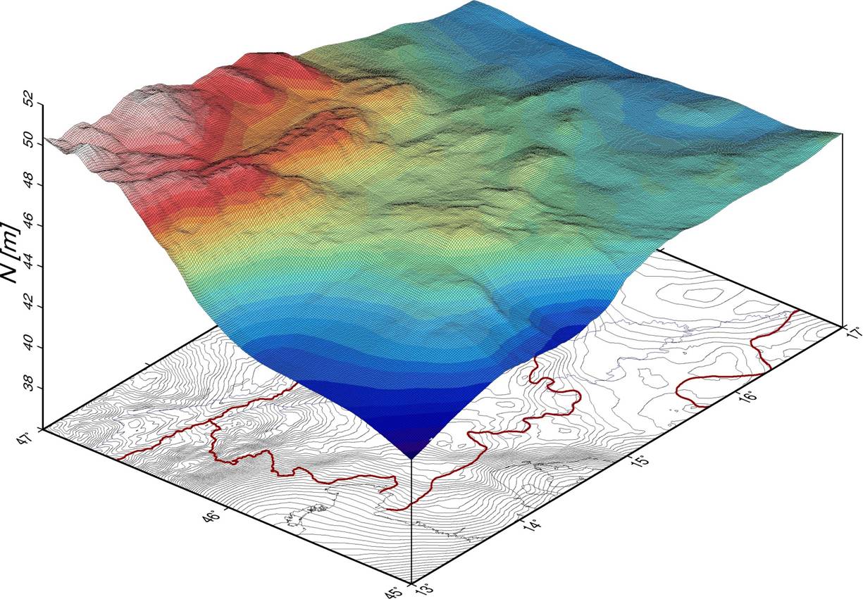
The dataset of the national digital geoid models of Slovenia includes data for: - the Slovenian absolute geoid model from the year 2000 (Slovenian SLOvenski Absolutni Model Geoida 2000) – SLOAMG2000 and - the Slovenian height reference surface from the year 2016 (SLOvenska Višinska Referenčna Ploskev 2016) – SLO-VRP2016/Koper. The models enable transformations between the ellipsoidal heights above the GRS80 ellipsoid in the geodetic datum D96 (ETRS89/D96) and the national height reference systems of: - normal orthometric heights in the height datum Trst – SVS2000/Trst and - normal heights in the height datum Koper – SVS2010/Koper. SLOAMG2000 is a hybrid geoid model (astrogravimetric model) computed by least-squares collocation in the framework of a remove-restore procedure with the use of global geopotential model EGM96. Its resolution is 1ʹ × 1,5ʹ and covers 13,25° < λ < 16,75° and 45,25° < φ < 47,00°. The average geoid undulation is 46,453 m. SLO-VRP2016/Koper is a hybrid quasi-geoid model. It is based on Stokes/Molodensky equations, the Fast Fourier Transform technique, and the use of global geopotential model EGM08. Its resolution is 30ʺ × 45ʺ and covers 13° < λ < 17° and 45° < φ < 47°. The average geoid undulation is 46,162 m. The outer accuracy (based on 871 control GNSS/levelling measurements along levelling lines) is up to 10 cm. The data in this dataset are available in GRI (Gravsoft), GRD (Surfer Grid), and XYZ formats, and – on the ISG (International Service for the Geoid) web page – also in the ISG format.
-

V zbirki državnih geodetskih točk se vodijo podatki o državnih geodetskih točkah, ki so povezane v hierarhično (po redovih) urejene: - državne horizontalne (trigonometrične) geodetske mreže, - državne GNSS-mreže, - državne višinske (nivelmanske) mreže ter - državne gravimetrične mreže. Državne geodetske točke služijo: - realizaciji državnih koordinatnih in višinskih referenčnih sistemov – tvorijo ogrodja koordinatnih sistemov oziroma referenčne sestave (izbrane podnize geodetskih točk najvišjih redov, prek katerih je državni koordinatni sistem pripet na fizično površje Zemlje), - navezavi geodetskih izmer na državne referenčne koordinatne oziroma višinske siteme v realnem času ali z naknadno obdelavo meritev, - povezavi med horizontalno in višinsko sestavino državnega prostorskega koordinatnega sistema in določitvi državnih višinskih referenčnih ploskev (točke za vpetje geoida), - nadzoru delovanja aktivnih GNSS-omrežij in storitev za določanje položaja ter preverjanju ustreznosti geodetskih instrumentov in druge merilne opreme (kontrolne GNSS-točke) in - povezavi med različnimi realizacijami državnih koordinatnih in višinskih referenčnih sistemov (vezne točke za datumske transformacije). Podatki o državnih geodetskih točkah vključujejo tip točke, red točke, metapodatke o izvedenih meritvah/izmerah in rezultate izračunov (tj. koordinate in/ali višino in/ali težni pospešek) ter podatke o načinu označitve točke in o njeni lokaciji v prostoru, ki so podani s topografijami geodetskih točk.
-
The dataset on the national spatial reference system (SRS) contains: - data on the national coordinate reference systems (CRS) and height reference systems (HRS), - data on datum transformations between different national coordinate reference systems and between different height reference systems, and - data on hierarchical geographic coordinate grids. The data on the national coordinate/height reference systems contain parameters defining: - national horizontal geodetic datums, including geometrical parameters of the Earth as a planet, the coreresponding reference surface – rotational ellipsoid – and national map projection, and - national height geodetic datum, including physical parameters of the Earth, the height reference surface – (quasi-)geoid – and types of the national height systems. The data on datum transformations contain: - detailed specifications on transformation models with equations and - the corresponding sets of transformation parameters. The data on the national CRSes, HRSes and datum transformations are also supported by the internationally standardized descriptions with unique codes within the EPSG Geodetic Parameter Dataset. Geographical coordinate grids are also available as graphical layers in the Shape format (SHP-files).