 TEST - Slovenski INSPIRE metapodatkovni sistem
Keyword
infoMapAccessService
30 record(s)
Type of resources
Categories
INSPIRE themes
Keywords
Contact for the resource
Formats
Scale
Resolution
-

WMS service providing view to Slovenia nacional addresses master level for ELF Cadastre Index Map (CIM), scale < 1:2.000
-
Javni spletni servisi omogočajo dostop do prosto dostopnih podatkov iz zbirk podatkov Geodetske uprave Republike Slovenije (http://www.gu.gov.si/).
-
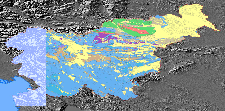
The pilot aplication service for calculating landslide susceptibility map and map of flood prone area.The harmonized geological map of Slovenia is a simplified version of the 1:250,000 scale Geological Map of Slovenia (Buser, 2009), which was compiled using the Basic Geological Map of Slovenia at a scale of 1: 100,000 (compiled by various authors between 1960's and 1980's) with the addition of new information by S. Buser. The map depicts the lithostratigraphic composition of Slovenia.The Basic Geological Map of Slovenia as a part of joint Basic Geological Map of SFR Yugoslavia presents lithological and stratigraphic characteristics of rocks, their relationships, age and other. It is a key to the understanding of the geology of Slovenia. It consists of 23 sheets at a scale of 1: 100,000.
-
WMS storitev za INSPIRE kanalizacijsko omrežje / US.SewerNetwork
-
WMS storitev za INSPIRE vodovodno omrežje / US.WaterNetwork
-
WMS storitev za INSPIRE površine pokrovnosti tal / LC.LandCoverSurfaces
-
WMS storitev za INSPIRE telekomunikacijsko omrežje / US.TelecommunicationsNetwork
-

WMS storitev za INSPIRE stavbe / BU.Building
-
WMS storitev za INSPIRE elektroenergetsko omrežje / US.ElectricityNetwork
-

WMS storitev za INSPIRE naslove / AD.Address