 TEST - Slovenski INSPIRE metapodatkovni sistem
Keyword
geologija
22 record(s)
Type of resources
Categories
INSPIRE themes
Keywords
Contact for the resource
Formats
Representation types
Scale
-
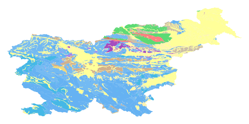
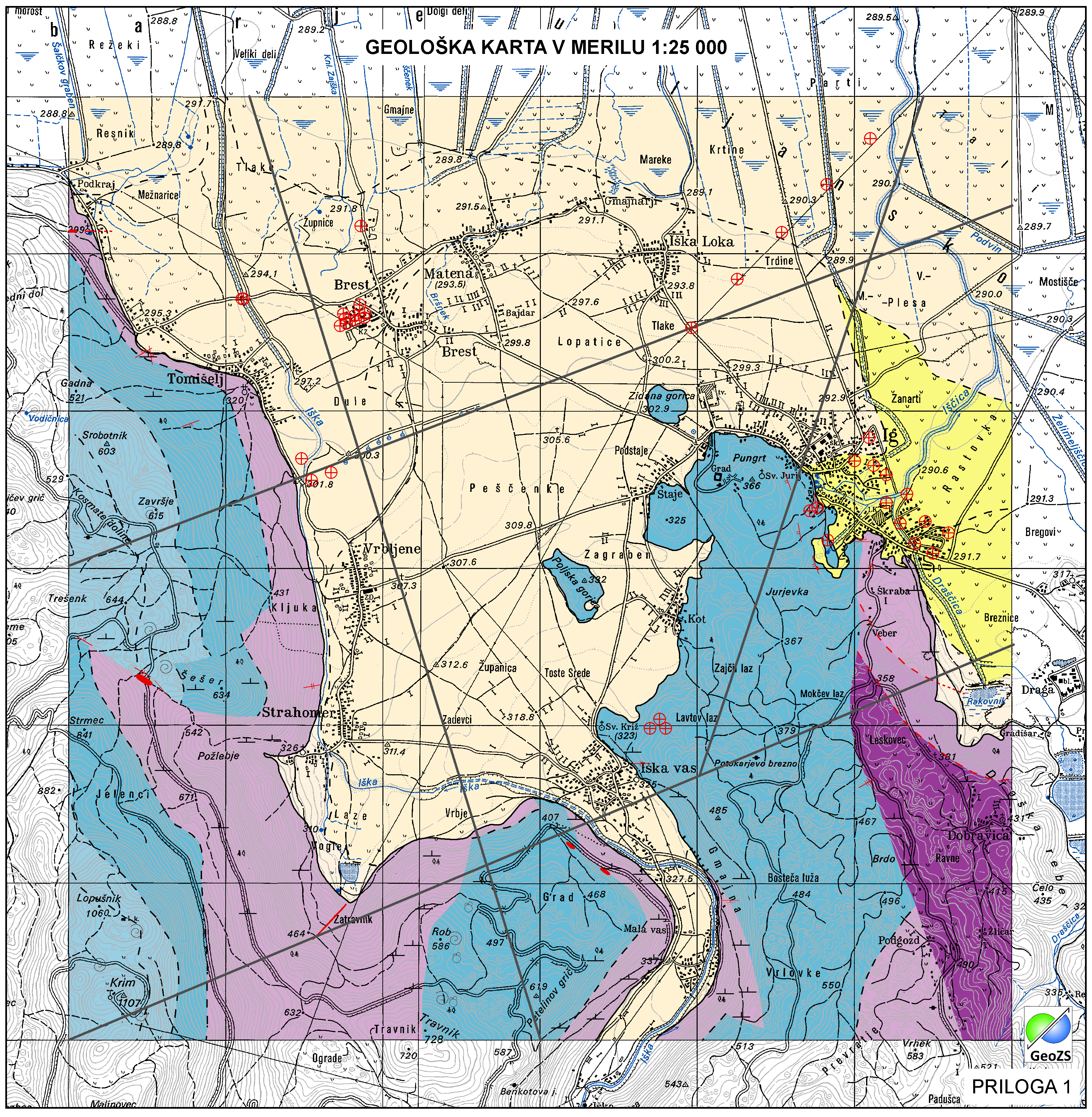
The harmonized geological map of Slovenia at a scale of 1:1,000,000 is a simplified version of the 1:250,000 scale Geological Map of Slovenia (Buser, 2009). The latter was compiled from the Basic Geological Map of Slovenia at a scale of 1: 100,000 (contributed by various authors between 1960's and 1980's and updated with new information gathered by S. Buser). The map is basically lithostratigraphic. The two layers incorporated in the map are lithostratigraphic units and major faults. The faults depicted on the map were selected using two criteria; regional extent and tectonic importance. The map presented here was edited specifically for the purpose of the OneGeology-Europe project by M. Bavec, M. Novak, M. Poljak, M. Trajanova and D. Skaberne.
-
The Basic Geological Map of Slovenia as a part of joint Basic Geological Map of SFR Yugoslavia presents lithological and stratigraphic characteristics of rocks, their relationships, age and other. It is a key to the understanding of the geology of Slovenia. It consists of 23 sheets at a scale of 1: 100,000.
-
Basic geological map of Yugoslavia presents lithological and stratigraphic characteristics of rocks, their relationships, age and other. It is a key to the understanding of the geology of Slovenia. It consists of 23 sheets, scale 1: 100.000.
-

Layer Geomorphologic Features shows the location of various types of geomorphological phenomena. Only point data are included.
-
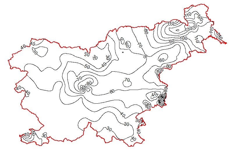
Map represents the calculated (surface) heat-flow density (HFD) in mW/m2 with topographic correction. It is made with data from 119 boreholes from the measured temperatures in the available boreholes and measured thermal conductivity on cored rock samples from the same boreholes. The pattern of the HFD isolines is affected by numerous parameters, particularly the thermal conductivity of rocks, rock permeability and fracturing, fluid content of the rocks, and all are reflected in the measured temperature gradient in the boreholes.
-
Layer shows discontinuities in the geological structure, and characterizes them according to their type and observation method.
-

Layer shows the zones where the rock is systematically fractured.
-
Product by the Pangeo project: http://www.pangeoproject.eu/ PanGeo provides information about the stability of the ground on which we live, work and play. Ground instability, or "geohazards", affect us all. They can be dangerous and costly, yet information on these phenomena can be difficult if not impossible to obtain. The PanGeo service provides entirely free access to geohazard information for many of the largest cities in Europe . The PanGeo service is aimed at local authorities, civil protection agencies, geological surveys, the public, insurers and businesses providing environmental and land reporting services. The service and products available are entirely free to use, even for commercial gain, providing appropriate credits are given (see licence terms). Information in PanGeo is derived from detailed analysis of local geological data combined with satellite measurements of ground movement.
-
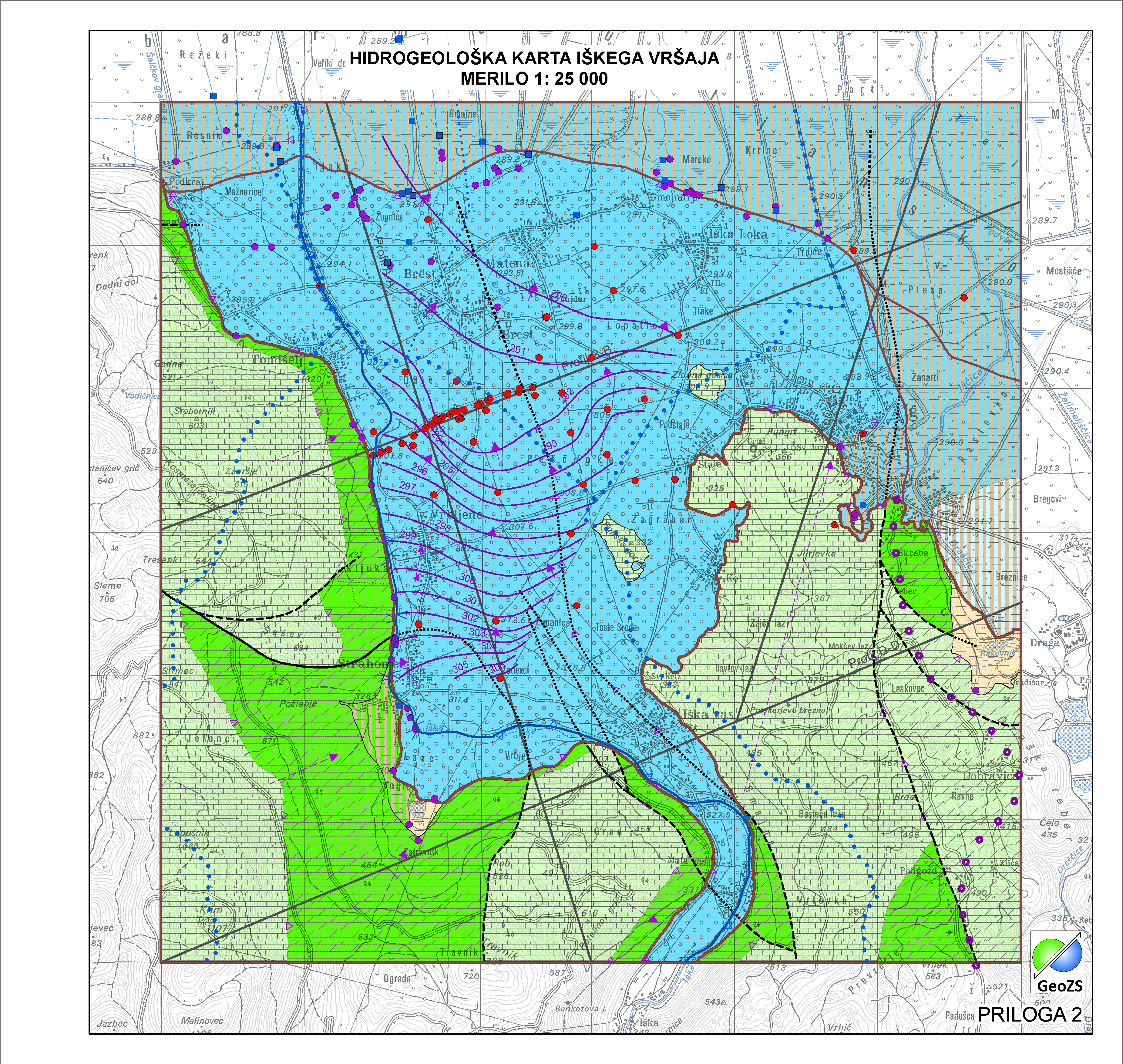
Po definiciji Vodne direktive je Vodno Telo Podzemne Vode (VTPodV), ali poenostavljeno "telo podzemne vode", razločna prostornina podzemne vode v vodonosniku ali več vodonosnikih. Določanje teles podzemne vode je bilo izvedeno po Pravilniku o metodologiji za določanje teles podzemnih voda sprejet v Uradnem listu RS pod št. 65/2003 in 63/2005. Karta vodnih teles podzemnih vod predstavlja 21 značilnih vodnih teles podzemnih voda na državnem nivoju v Sloveniji, ki pripada dvema vodnima območjema (Donava in Jadranske reke). Karta vključuje tudi 168 vodonosnih sistemov, ki gradijo vodno telo podzemne vode na državnem nivoju. Na obravnavanem območju so bile meje vodnih teles prilagojene na merilo 1:25.000.
-

Gladina podzemne vode (hidroizohipse) predstavljajo srednje vodno stanje gladine podzemne vode v plitvih opazovalnih objektih (plitva gladina podzemne vode). Meritve so bile izvedene v zelo visokem (24.10.2014 - v okviru projekta Izdelava metodologije in pilotnega vnosa hidrogeološke karte v M 1:25.000) in zelo nizkem (22.11.2011 - v okviru Projekta INCOME) vodnem stanju, srednja vrednost meritev. Pomembno: meritve so bile izvedene v času črpanja v Vodarni Brest.