 TEST - Slovenski INSPIRE metapodatkovni sistem
Keyword
Geologija
29 record(s)
Type of resources
Categories
INSPIRE themes
Keywords
Contact for the resource
Formats
Representation types
Scale
Resolution
-
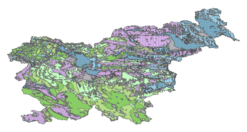
Hydrogeological map of Slovenia 1:250.000 represent hydrogeological characteristics of overlaying strata. The identification and classification of strata is based on LAWA classification. Hydrogeological units of LAWA classification are defined on type of porosity and basic petrographical composition. Geological strata with kartic porosity were additionaly classified after karstification stage.
-
Prikaz hidrogeoloških enot po IAH klasifikaciji, kjer je težišče v prvi vrsti na tipu poroznosti in obsežnosti in v drugi vrsti na izdatnosti vodonosnikov.Karta je bila izdelana z namenom pridobiti podlago za izdelavo Karte vodonosnikov v merilu 1:250.000 ter kot pomoč pri strategiji izrabe podzemne vode ter zaščite in upravljanja z viri pitne in tehnološke vode. Karta je bila izdelana z namenom pridobiti podlago za izdelavo Karte vodonosnikov v merilu 1:250.000 ter kot pomoč pri strategiji izrabe podzemne vode ter zaščite in upravljanja z viri pitne in tehnološke vode.
-
Baza pokrovnosti tal CLC 2006 je narejena iz kombinacije baze CLC 2000 in baze sprememb v pokrovnosti tal med letoma 2000 in 2006. Baza sprememb je bila narejena s pomočjo vizualne interpretacije satelitskih posnetkov. V primeru odkrite napake v bazi CLC 2000 se je popravila tudi ta baza. Rezultat tega je popravljena baza CLC 2000. Podatki so namenjeni za vsedržavno podatkovno bazo rabe in pokrovnosti tal, ki je primerljiva z ostalimi državami v Evropi. Primeri uporabe v Sloveniji: - za poročanje Evropski agenciji za okolje: o vodah, pozidavi in prekrivanju tal, o stanju morja in obale, Evropski komisiji: pri interkalibracijski vaji merilnih mest na površinskih vodotokih, - za posodobitev mreže monitoringa kakovosti podzemnih voda, - kot podlaga za izvajanje monitoringa tal, - kot indikator pokrovnosti, - kot osnovni sloj projekta Inspire, - kot podlaga pri projektu Nopolu, - kot podlaga za Naturo 2000. Primeri uporabe v Evropi: - modeliranje onesnaženosti tal v črnem trikotniku na nemško-češko-poljski tromeji - ugotavljanje nevarnosti erozije prsti na Slovaškem, - modeliranje koncentracije fosforja v rekah na Slovaškem, Madžarskem in v Romuniji, - razmejitev manj ugodnih kmetijskih površin na Poljskem, - izdelava turistične karte Slovaške, - ugotavljanje sprememb rabe pokrajine na Slovaškem. Področja uporabe CLC v Evropi: - prostorske analize, - vrednotenje in ocenjevanje podatkov o pokrovnosti, rabi tal in kakovosti zemljišč, - prikaz sprememb, - analiza pokrajin, - pokrajinski indikatorji, - analiza vodotokov in rabe mokrišč, - razvoj GIS za potrebe NATURA 2000 - ugotavljanje sprememb za potrebe določanja habitatov in ocen izpostavljenosti ranljivih območij, - ocena CO2 emisij, - podatki o pokrovnosti okrog merilnih postaj, - nova dodelitev parametrov kakovosti zraka glede na podatke o pokrovnosti, - vpliv transporta, odvzem zemljišč za potrebe prometa, - vpliv na zavarovana območja.
-
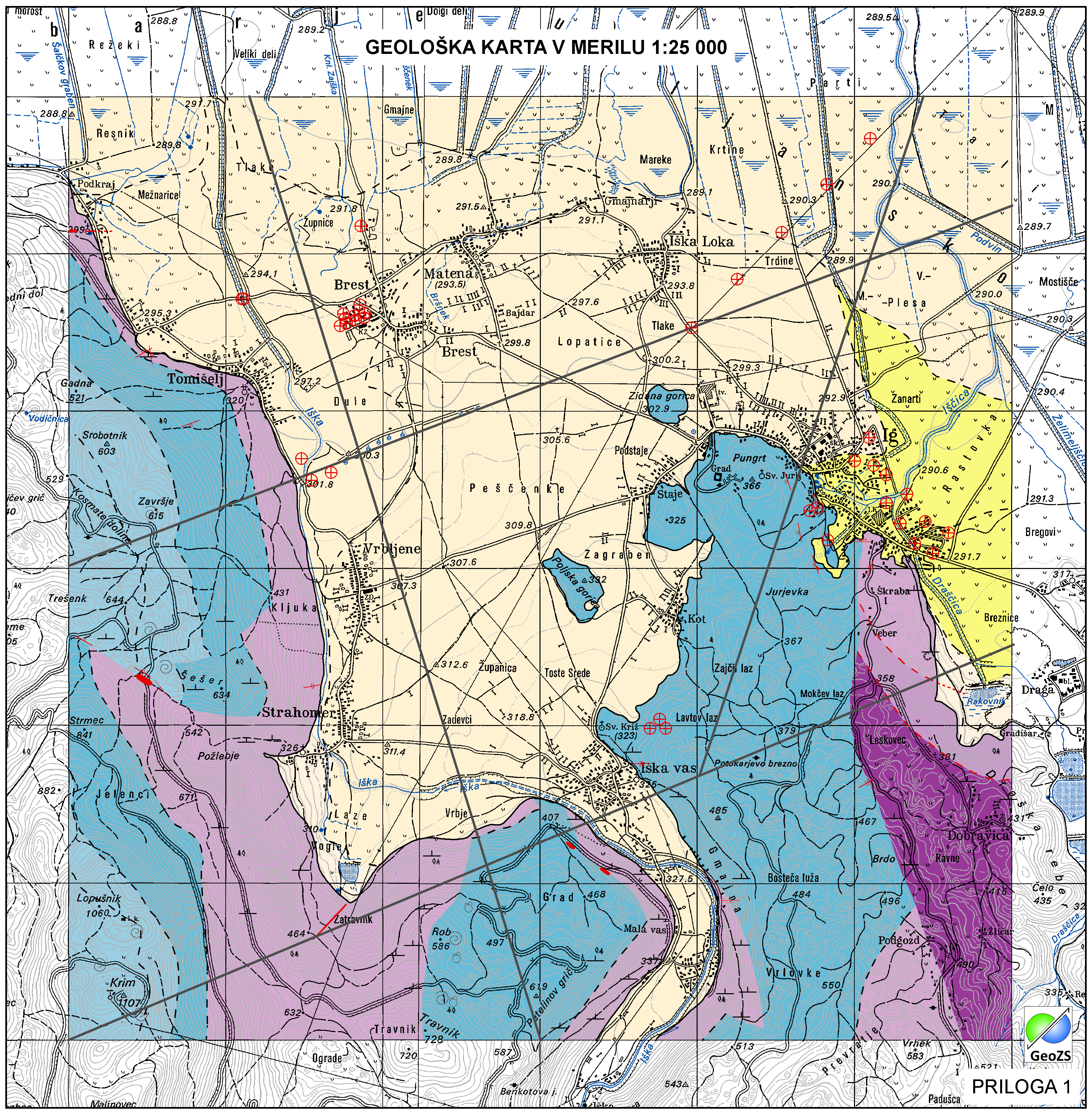
Basic geological map of Yugoslavia presents lithological and stratigraphic characteristics of rocks, their relationships, age and other. It is a key to the understanding of the geology of Slovenia. It consists of 23 sheets, scale 1: 100.000.
-
Mineral deposits and resources
-
Karta podaja potencialna plazovita območja za območje celotne Slovenije v šestih razredih verjetnosti pojavljanja plazov; ni verjetnosti, zelo majhna verjetnost, majhna verjetnost, srednja verjetnost, velika verjetnost, zelo velika verjetnost. Zanesljivost napovedi je približno 0,88.
-
Layer Geomorphologic Features shows the location of various types of geomorphological phenomena. Only point data are included.
-

Hidrogeološki objekti vrtine predstavljajo hidrogeološke objekte, ki jih je naredil človek.
-
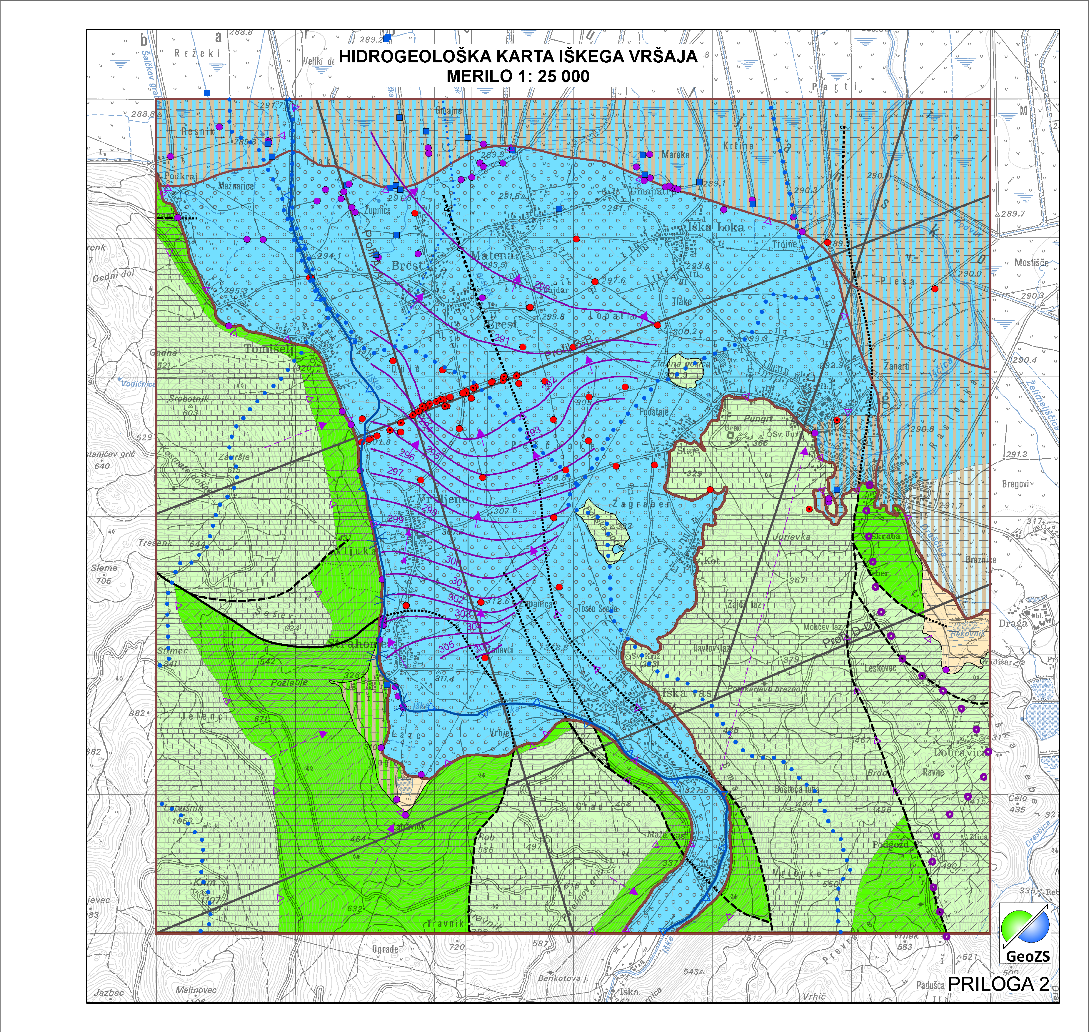
Vodonosni sistem je ozemlje z geološko zgradbo, v kateri nastopata vsaj dva različna vodonosnika, z ali brez medsebojne hidravlične povezave. Na obravnavanem območju so bile meje vodonosnih sistemov prilagojene na merilo karte 1:25.000. Namenjena so zanesljivemu ugotavljanju stanja celotne pomembne prostornine podzemnih voda v državi in doseganja okoljskih ciljev, ki jih predpisuje Vodna direktiva.
-

Gladina podzemne vode (hidroizohipse) predstavljajo srednje vodno stanje gladine podzemne vode v plitvih opazovalnih objektih (plitva gladina podzemne vode). Meritve so bile izvedene v zelo visokem (24.10.2014 - v okviru projekta Izdelava metodologije in pilotnega vnosa hidrogeološke karte v M 1:25.000) in zelo nizkem (22.11.2011 - v okviru Projekta INCOME) vodnem stanju, srednja vrednost meritev. Pomembno: meritve so bile izvedene v času črpanja v Vodarni Brest.