 Slovenski INSPIRE metapodatkovni sistem
denominator
10000
2 record(s)
Type of resources
Categories
INSPIRE themes
Keywords
Formats
Representation types
Scale
-
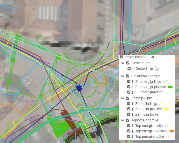
The Consolidated Cadastre of Public Infrastructure is a register in which facilities of public infrastructure and network connection points of the public communications network are recorded. For each public infrastructure facility, data are maintained on the type and category of the facility, its location, identification data, and information on the operator of the facility. For each network connection point, identification data, location data, information on the minimum capacity of the network connection point, and information on the owner of the network connection point are recorded. All operators of public infrastructure and owners of network connection points are required to submit the relevant data to the Consolidated Cadastre of Public Infrastructure. Public access to data from the Consolidated Cadastre of Public Infrastructure is ensured for all users. The primary purpose of establishing the Consolidated Cadastre of Public Infrastructure is to provide an overview of spatial occupancy by public infrastructure facilities and public communications network connection points across the entire territory of the country. This will, in the future, enable more efficient spatial planning, safer implementation of interventions in space, and more economical management of infrastructure assets.
-
Register prostorskih enot je integrirana podatkovna baza z lokacijskimi in opisnimi podatki o naslovih in prostorskih enotah (občine, naselja, upravne enote, poštni okoliši, šolski okoliši, statistične regije, kohezijske regije, ožji deli občin (četrtne skupnosti, krajevne skupnosti, vaške skupnosti), enote za državnozborske volitve (državnozborske volilne enote, državnozborski volilni okraji, državnozborska volišča), enote za lokalne volitve (lokalne volilne enote, lokalna volišča) in ulice. V register prostorskih enot se vpisujejo naslednji podatki o prostorskih enotah: vrsta; identifikacijska številka; ime, meje in površina. V register prostorskih enot se vpisujejo naslednji podatki o ulicah: ime; identifikacijska številka; geolokacija.