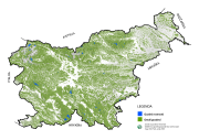
 Slovenski INSPIRE metapodatkovni sistem
denominator
5000
36 record(s)
Type of resources
Categories
INSPIRE themes
Keywords
Contact for the resource
Formats
Representation types
Scale
Resolution
-
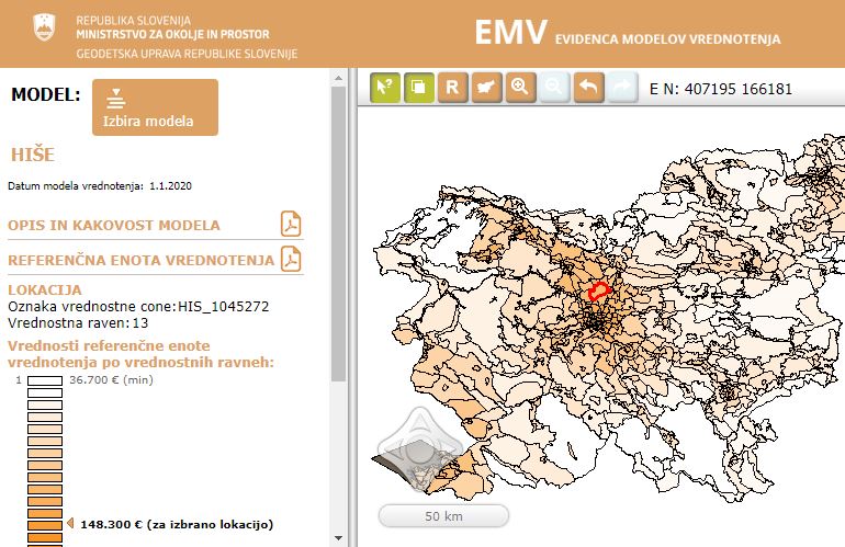
Real Estate Valuation Models Database is a public database of real estate valuation models. The valuation model defines the impact of different real estate characteristics on a market value of the real estate.
-
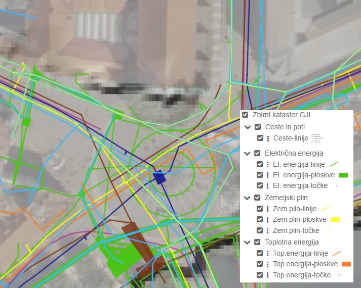
The Consolidated Cadastre of Public Infrastructure is a register in which facilities of public infrastructure and network connection points of the public communications network are recorded. For each public infrastructure facility, data are maintained on the type and category of the facility, its location, identification data, and information on the operator of the facility. For each network connection point, identification data, location data, information on the minimum capacity of the network connection point, and information on the owner of the network connection point are recorded. All operators of public infrastructure and owners of network connection points are required to submit the relevant data to the Consolidated Cadastre of Public Infrastructure. Public access to data from the Consolidated Cadastre of Public Infrastructure is ensured for all users. The primary purpose of establishing the Consolidated Cadastre of Public Infrastructure is to provide an overview of spatial occupancy by public infrastructure facilities and public communications network connection points across the entire territory of the country. This will, in the future, enable more efficient spatial planning, safer implementation of interventions in space, and more economical management of infrastructure assets.
-
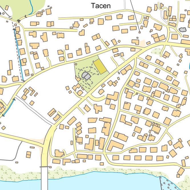
The collection of topographic data is maintained in the form of the National Topographic Model (DTM), which contains graphical and attribute-based topographic data on features that correspond to the accuracy of the 1:5,000 scale. The DTM includes topographic data for the territory of Slovenia in compliance with INSPIRE guidelines. The DTM also comprises geographical names and a digital terrain model. DTM data can be used for geolocating other spatial data, as a base for the display of graphical components of municipal spatial planning documents, and for the purposes of digital cartography. The data can also be linked to datasets from various administrative sectors.
-
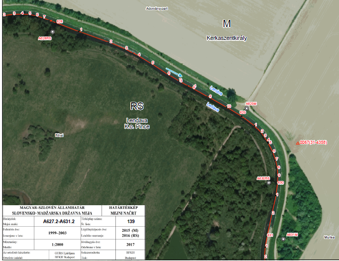
Database contains attributes about border points of a national border. These points are marked (physically on the field - border markers) and unmarked (breaking points). Border points indicate the national border of the Republic of Slovenia. Coordinates are defined in the coordinate system D48, Gauß-Krügerjev projection. National Border Record is the fundamental register of the national border points. It contains data about country code, sector, type and position of the border mark, its label, coordinates in the D48/GK and D96/TM coordinate system and the neighbouring country reference system, the possible distance from the border line and the distance to the next border mark. National Border Record is established based on the Real Estate Cadastre Act - ZKN (Official Journal of RS, No. 54/2021). Data from the National Border Record serves as a graphical representation of the national border, for the harmonization of Land Cadastre data and the Administrative Units Register with the national border.
-
Sloj vsebuje prijave kmetovalcev na zadnjo zbirno vlogo (ZV)
-
Podatkovni niz prikazuje grafične in atributne podatke o gozdovih s posebnim namenom brez ukrepanja (gozdnih rezervatih), ki jih uporabnik prejme v izmenjevalni datoteki. Podatki katastra gozdnih rezervatov se vodijo v centralni bazi, ta pa se povezuje z drugimi evidencami, ki jih vodita Zavod za gozdove in geodetska uprava.
-
Podatkovni niz prikazuje prispevne površine občutljivih območij zaradi evtrofikacije po Uredbi o emisiji snovi pri odvajanju odpadne vode iz komunalnih čistilnih naprav (Uradni list RS, št. 45/07). Z uredbo je v slovenski pravni red prenesena Direktiva Sveta z dne 21. maja 1991 o čiščenju komunalne odpadne vode (91/271/EGS), ki zahteva določitev občutljivih območij, za katera se pred neposrednim ali posrednim odvajanjem v vode določijo posebne zahteve glede čiščenja komunalnih odpadnih voda. Posebne zahteve veljajo na celotnih prispevnih območnih vodnih teles, ki so določena kot občutljiva zaradi evtrofikacije.
-
Evidenca obsega seznam merilnih mest v mreži državnega monitoringa (ARSO) za spremljanje kakovosti površinskih voda. Vsako merilno mesto predstavlja v evidenci zapis, ki ga sestavljajo šifra merilnega mesta, ime merilnega mesta, ime vodotoka, vodno telo, ki ga sestavljajo šifra vodnega telesa, ime povodja ali porečja, kamor spada vodno telo, ime vodotoka, kateremu pripada vodno telo, ime vodnega telesa, vrsta in tip vodnega telesa, nadmorska višina, Gauß-Krügerjeve in ETRS koordinate lokacije.
-
Register zemljepisnih imen je osnovni državni geoinformacijski sloj. Vsebuje imena objektov, ki imajo neko časovno, zgodovinsko, etnološko ali družbeno uveljavljeno identiteto, kar pomeni, da so bolj ali manj trajna v okolju. V register so zajeta imena krajev (imena naseljenih krajev, njihovih delov in imena zgradb), hidronimi (vodna imena), oronimi (imena reliefnih oblik) in horonimi (imena krajinskih delov). Ob vzpostavitvi registra so bila zemljepisna imena zajeta iz temeljnih topografskih načrtov v merilu 1 : 5.000 in 1 : 10.000, iz državnih topografskih kart v merilu 1 : 25.000 in iz državnih preglednih kart v merilih 1 : 250.000 in 1 : 1.000.000. V register zemljepisnih imen se vpisujejo tudi zemljepisna imena, katerih obstoj je nedvoumen, niso pa evidentirana na kartografskih virih, s katerih so bili prevzeti podatki za register in tudi zemljepisna imena, ki jih je standardizirala Komisija za standardizacijo zemljepisnih imen. REZI služi kot samostojni geoinformacijski sloj za lociranje objektov v prostor, kot nadgradnja ostalih geoinformacijskih slojev z zemljepisnimi imeni, za aplikacije na področju topografije, kartografije ter za geografske, statistične in jezikoslovne analize.
-
Plovba na motorni pogon po celinskih vodah v Republiki Sloveniji je prepovedana. Na posameznih celinskih vodah ali njihovih delih pa je plovba na motorni pogon lahko izjemoma dovoljena, če je tako določila vlada.